Huub Eggen · @huubeggen
339 followers · 207 posts · Server socialserver.scienceView by @nasa satellite #SuomiNPP yesterday afternoon of cloud formations west of #BajaCalifornia. Nice small low pressure area, subtle Von Kármán vortices downwind from #Guadelupe island, and - only visible after enhancement (2nd pic) a #glory (upper left of centre). A light diffraction phenomenon in the cloud droplets when the sun is right behind te satellite. One can see such a glory often from airplanes. Also visible shiptrails (at upper left). Original https://wvs.earthdata.nasa.gov/api/v1/snapshot?REQUEST=GetSnapshot&TIME=2023-07-01T00:00:00Z&BBOX=13.5,-131.2907,31.909,-109.4738&CRS=EPSG:4326&LAYERS=VIIRS_SNPP_CorrectedReflectance_TrueColor,Coastlines_15m&WRAP=day,x&FORMAT=image/jpeg&WIDTH=4965&HEIGHT=4189&ts=1688299063565
#suominpp #bajacalifornia #guadelupe #glory
Pierre Markuse · @pierre_markuse
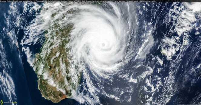
463 followers · 138 posts · Server mastodon.world🔵 Tropical Cyclone Freddy near #Madagascar🇲🇬 21 February 2023 #SuomiNPP🛰️ #VIIRS Full-size ➡️ https://flic.kr/p/2oibru4 #OpenData #SciComm #RemoteSensing #Freddy #CycloneFreddy Image is about 1,950 kilometers wide
#madagascar #suominpp #viirs #opendata #scicomm #remotesensing #freddy #cyclonefreddy
Klimastreik Schweiz 🔥 · @klimastreik
799 followers · 635 posts · Server climatejustice.globalRT @DisastersChart
We now have a series of maps of the flood situation in Zambia: http://bit.ly/3HnxdzZ
The maps use data from the #RCMSatellites, #SuomiNPP and #Sentinel2 to estimate the extent of flooding.
#rcmsatellites #suominpp #Sentinel2
BakersRelay · @BakerRL75
216 followers · 1321 posts · Server m.ai6yr.orgFROM UW-MADISON CIMSS - Before (01 December) and after (04 and 05 December) #SuomiNPP #VIIRS Day/Night Band images showed the reduction of nighttime city lights following the vandalism of power substations in #MooreCounty North Carolina on Saturday 03 December: cimss.ssec.wisc.edu/satellite-blog… Via @SSECRealEarth


