GregCocks · @GregCocks
612 followers · 556 posts · Server techhub.socialPositional Accuracy Assessment Of Digital Orthophoto Based On UAV Images - An Experience On An Archaeological Area
--
https://doi.org/10.3390/heritage4030071 <-- shared paper
--
#GIS #spatial #mapping #archaeology #archaeological #heritage #heritagebuildings #ancienthistory #culturalheritage #imagery #visualisation #orthoimagery #UAV #documentation ##accuracy #quality #precision #survey #surveying #KubadAbadPalace #Beyşehir #Konya #Anatolian #SeljukPalace #metrics #orthophoto #orthophotoaccuracy #archaeologicalheritage #ASPRS #Turkey
#gis #spatial #mapping #archaeology #archaeological #heritage #heritagebuildings #ancienthistory #culturalheritage #imagery #visualisation #orthoimagery #uav #documentation #accuracy #quality #precision #survey #surveying #kubadabadpalace #beysehir #konya #anatolian #seljukpalace #metrics #orthophoto #orthophotoaccuracy #archaeologicalheritage #asprs #turkey
GregCocks · @GregCocks
612 followers · 555 posts · Server techhub.socialASPRS Approves Edition 2 of the ASPRS Positional Accuracy Standards for Digital Geospatial Data
--
https://www.asprs.org/revisions-to-the-asprs-positional-accuracy-standards-for-geospatial-data-2023 <-- shared technical article
--
https://publicdocuments.asprs.org/PositionalAccuracyStd-Ed2-V1 <-- download the current ASPRS current document
--
#GIS #spatial #mapping #gischat #ASPRS #precision #accuracy #standards #data #spatialdata #PositionalAccuracyStandards #survey #surveying #workinggroup #confidencelevel #metrics #measurement #checkpoints #groundcontrol #VWA #remotesensing #LiDAR #3dmapping #UAS #photogrammetry #geomorphometry
#gis #spatial #mapping #gischat #asprs #precision #accuracy #Standards #data #spatialdata #positionalaccuracystandards #survey #surveying #workinggroup #confidencelevel #metrics #measurement #checkpoints #groundcontrol #vwa #remotesensing #lidar #3dmapping #uas #photogrammetry #geomorphometry
RJ Rowe · @privateshufti
4 followers · 6 posts · Server ecoevo.socialI've done some of this before, am signed up to do a module in terrestrial ecology at the Open University from Oct, & also volunteering with a PhD student surveying aquatic invertebrates & plants in a #chalkstream restoration project from Sept.
Plan A is to supplement my pension through freelance work in this field, but I need to work out if this is possible before taking the plunge. Any advice would be gratefully received!
#Ecology #Habitat #Invertebrates #Surveying
/2
#chalkstream #ecology #habitat #invertebrates #surveying
schrockg · @schrockg
24 followers · 65 posts · Server mapstodon.spaceGrowing a scanning focused business. How Bruno Mathias de Oliveira of Futuro3D started with one scanner, and grew to become one of the most successful scanning busniesses in Brazil and South America.
http://gogeomatics.ca/growing-a-scanning-focused-business/
#laserscanning #leicageosystems #geomatics #surveying #surveylife
#laserscanning #leicageosystems #geomatics #surveying #surveylife
grob 🇺🇦 · @grob
168 followers · 7397 posts · Server mstdn.socialIn 1918 the US Coast and Geodetic Survey, an official scientific government agency, determined the geographical center of the 48 contiguous US states by balancing a cardboard cutout shaped like the US on a stick. The method is considered to be accurate with an error of at most 20 miles. The center determined this way is near Lebanon, Kansas and only 12 miles from the Nebraska border. Spicy.
https://en.m.wikipedia.org/wiki/Geographic_center_of_the_United_States
#geography #US #science #surveying
#surveying #Science #US #geography
Matt Malone · @MattMalone
171 followers · 120 posts · Server mapstodon.space👍🏼 Gonna make a wild guess that one of my fellow #surveying or #GIS colleagues here in Michigan has this awesome plate that I spied recently.
schrockg · @schrockg
24 followers · 64 posts · Server mapstodon.spaceSurveying is not a game. However, a game-like virtual environment could be a valuable tool for training, site safety, planning, project management, and more.
#surveying #geomatics #virtualreality #training
https://gogeomatics.ca/ready-surveyor-one/
#surveying #geomatics #VirtualReality #training
some random Surveyor · @testusterror
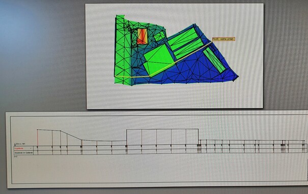
10 followers · 28 posts · Server norden.socialThis is a digital terrain model. ( #dgm #digitalesgeländemodell )
the brighter the colour, the higher the area.
Matter of fact, the deepest area there is at 0.00m above general height in the heights system of germany . Deutsches Haupt Höhen Netz ( #dhhn-2016nh )
The property is close to the "Elbe" .
the small buildings are Greenhouses.
and the picture shows a cross section and profile of a certain line.
#dgm #digitalesgelandemodell #dhhn #surveying
schrockg · @schrockg
24 followers · 56 posts · Server mapstodon.spaceIt was only 5 years ago when no-calibration (GNSS+IMU) tilt compensation for surveying and constuction rovers first hit the market. And now, it is an almost universal feature for new rovers. I spent some time looking at the adoption and impact of this technology; when users recommend to use it, and when not to.
Oh, and that 'click-baitey' title on the magazine cover was not my idea 🙄
#GNSS #imu #surveying #constuction #geomatics
schrockg · @schrockg
24 followers · 55 posts · Server mapstodon.spaceMultiple National Geodetic Survey (NGS) sessions today at the FIG - International Federation of Surveyors Working Week 2023. NGS Training Coordinator Erika Little presents on new training options, for example the transition from mandatory instructor lead OPUS Projects courses to self-paced online as an option. #surveying #geomatics #geodesy @xyht @GoGeomatics
#surveying #geomatics #geodesy
schrockg · @schrockg
24 followers · 54 posts · Server mapstodon.spaceTrimble's Bryn Fosburgh at FIG Working Week 2023. He addressed enabling tech like AI, that will transform us, not replace us; recalling that GPS did not, despite some owrdicting it would. #surveying #geomatics #ai #innovation @xyHt @GoGeomatics
#surveying #geomatics #ai #innovation
schrockg · @schrockg
24 followers · 53 posts · Server mapstodon.spaceNational Society of Professional Surveyors (NSPS) Executive Director Timothy Burch kicks off the opening ceremony of the FIG - International Federation of Surveyors (Fédération Internationale des Géomètres), working week 2023, in Orlando. He noted that the last time the U.S. hosted FIG was in 2002, in Washington DC. He quipped about the contrast between the host cities: "One has statues of presidents, the other has statues of a mouse." #surveying #mapping #geomatics xyHt GoGeomatics
#surveying #mapping #geomatics
schrockg · @schrockg
24 followers · 52 posts · Server mapstodon.spaceFascinating technical session: Reference Frames in Pratice. Moon Geodesy included. FIG - International Federation of Surveyors Working Week 2023. #surveying #mapping #geodesy #geomatics
#surveying #mapping #geodesy #geomatics
schrockg · @schrockg
24 followers · 51 posts · Server mapstodon.spacePresidents Report: FIG - International Federation of Surveyors Working Week 2023; Dr. Diane A Dumashie FRICS, CEDR, APM, PhD, BSc . Highlights: work with UN-GGIM Subcommittee on Geodesy, Young Surveyors Network, and new publications. #surveying #geomatics #mapping #geospatial
#surveying #geomatics #mapping #geospatial
schrockg · @schrockg
24 followers · 50 posts · Server mapstodon.spaceRoll call of the general assembly kickoff session of FIG 2023. Orlando.
FIG - International Federation of Surveyors (Fédération Internationale des Géomètres), working week 2023 28 May - June 1). This annual global event is hosted by different countries and has not been hosted by the U.S. since 2002.
#surveying #mapping #geomatics NSPS Young Surveyors Network (YSN), xyHt, GoGeomatics
#surveying #mapping #geomatics
some random Surveyor · @testusterror
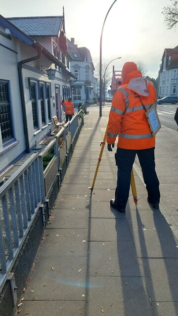
9 followers · 25 posts · Server norden.socialThis is my colleague and me(handling the #surveying machine/device/instrument) at work.
We were transferring a specific hight to another location.
Used Device: #Leica #geosystems #TS16 (Totalstation)
Capable of more than just measuring.
Tracking, taking Georeferenced Pictures with 3D dots showing already measured point,
Display architect's files, a.s.o.
(Picture taken January2023)
#surveying #leica #geosystems #ts16
schrockg · @schrockg
21 followers · 46 posts · Server mapstodon.spaceProfile of a domestic drone maufacturer. With roots in the motion picture industry. Freefly Systems #uas #uav #rpas #aerialmapping #surveying #geomatics https://bt.e-ditionsbyfry.com/publication/?m=36207&i=789316&p=16&ver=html5
#uas #uav #rpas #aerialmapping #surveying #geomatics
schrockg · @schrockg
21 followers · 45 posts · Server mapstodon.spaceLevel 4 autonomy in a drone system. With an intersting backstory that involes a sci-fi film. Exyn Technologies #uas #uav #drones #surveying #geomatics #autonomy https://bt.e-ditionsbyfry.com/publication/?m=36207&i=789316&p=14&ver=html5
#uas #uav #drones #surveying #geomatics #Autonomy
PR🪸🪼🧑💻 · @peterrenshaw
323 followers · 1121 posts · Server ioc.exchangeThis is why you can get a 1:2000 Ordinance map for any part of the UK.
“For centuries, though, no one had set out to systematically and accurately map the British isles in their entirety. It was not until the 19th century that os created the first comprehensive, detailed picture of #Britain. Just as today’s paper os #maps fit together in a jigsaw that stretches over the country, when os began its #cartographic project around 1800 it progressed sheet by sheet. The task would take eight decades and involved considerable hardship for the hundreds of #surveyors employed to carry it out.”
#ordinance #os / #cartography / #surveying <https://economist.com/interactive/britain/2023/04/06/how-intrepid-victorian-surveyors-mapped-the-length-and-breadth-of-britain>
#britain #maps #cartographic #surveyors #ordinance #os #cartography #surveying
schrockg · @schrockg
20 followers · 43 posts · Server mapstodon.spaceThe evolution of modern surveying instruments experienced an inflection point in the early 20th Century when multiple sciences converged. A visit to an optics museum spurred a deeper look into one such backstory. https://bt.e-ditionsbyfry.com/publication/?m=36207&i=786435&p=22&ver=html5
#surveying #geomatics #theodolite #zeiss #jena
#surveying #geomatics #theodolite #zeiss #jena


