
GregCocks · @GregCocks
567 followers · 503 posts · Server techhub.social
Instructional Videos on Using The [USGS’s] National Map [Open Data] Products and Services [3DEP Elevation, Hydrology, etc]
--
https://www.usgs.gov/programs/national-geospatial-program/training <-- shared technical training resource
--
https://www.usgs.gov/programs/national-geospatial-program/national-map <-- background to the USGS’s Accessible National Map Open Data
--
#GIS #spatial #mapping #USGS #opendata #elevation #hydrography #hydrology #NGTOC #NGP #3DEP #3DHP #topoBuilder #USA #gischat #TNM #TheNationalMap #products #services #dataportal #tutorials #tutorial #trainingvideos #videos #learning #continuingeducation #education #educationandtraining #free #videolessons #videolearning #topographic #topographicmaps #instructional
@usgs
#gis #spatial #mapping #usgs #opendata #elevation #hydrography #hydrology #ngtoc #ngp #3dep #3dhp #topobuilder #USA #gischat #tnm #thenationalmap #products #services #dataportal #tutorials #tutorial #trainingvideos #videos #learning #continuingeducation #education #educationandtraining #free #videolessons #videolearning #topographic #topographicmaps #instructional
GregCocks · @GregCocks
281 followers · 366 posts · Server techhub.social
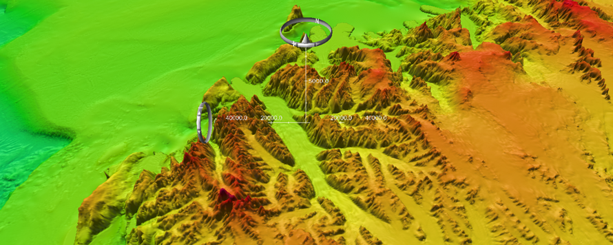
3D Nation Study Hub Site Now Available! [NOAA + USGS]
--
https://nauticalcharts.noaa.gov/updates/3d-nation-study-hub-site-now-available/ <-- NOAA technical article / ‘press release’
--
https://iocm.noaa.gov/planning/3DNationStudy.html <-- NOAA 3D Nation Elevation Requirements and Benefits Study
--
#GIS #spatial #mapping #elevation #opendata #bathymetry #webportal #data #businesscase #offshore #benefits #benefitsstudy #3D #data #terrestrial #marine #offshore #hydrospatial #usecase #national #USA #datasets #datacollection #planning #3DNation #3DTNM #3DEP #topobathy #topographic #bathymetric #coast #coastal #businessuse #maps #CoNED #gischat #NOAA #USGS
@NOAA @USGS
#gis #spatial #mapping #elevation #opendata #bathymetry #webportal #data #businesscase #offshore #benefits #benefitsstudy #3d #terrestrial #marine #hydrospatial #usecase #national #USA #datasets #datacollection #planning #3dnation #3dtnm #3dep #topobathy #topographic #bathymetric #coast #coastal #businessuse #Maps #coned #gischat #noaa #usgs

Derek Law · @GIS_Bandit
230 followers · 293 posts · Server mastodon.world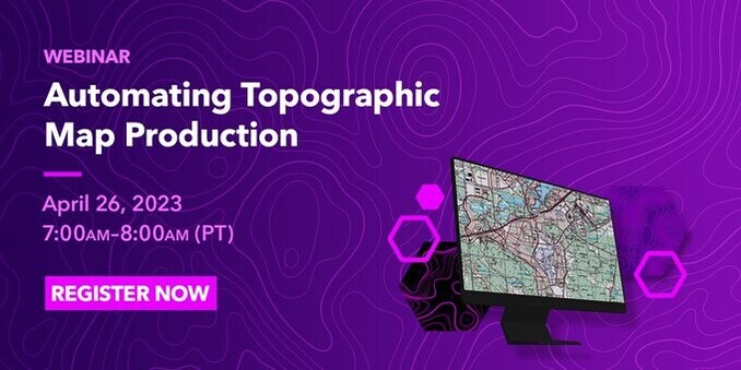
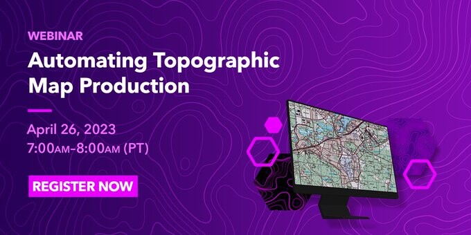
In 1 week, #Esri webinar: Automating #Topographic #Map Production https://tinyurl.com/2s39zu46
#automation #mapping #cartography #ArcGISPro #GIS #esri #arcgis #GIO #TheScienceOfWhere #MapSeries #GISchat #geospatial #mapstodon
#esri #topographic #map #automation #mapping #cartography #arcgispro #GIS #arcgis #GIO #TheScienceOfWhere #mapseries #gischat #geospatial #mapstodon

Alan McConchie · @alan
813 followers · 163 posts · Server subdued.social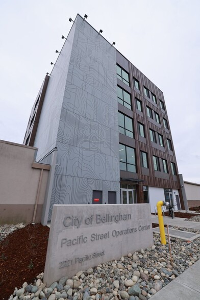
#BellinghamWA has a new five-story public works building with a huge #topographic #map of the city on one side.
Via the city's FB page: "The new five-story building at the corner of Pacific and Carolina streets, part of the Pacific Street Operations Center. The left corner of the building features a topographic map of Bellingham, designed by David Heck, RMC Architects, fulfilling the City's 'One Percent for the Arts' requirement for the new operations center."
#bellinghamwa #topographic #map
GregCocks · @GregCocks
145 followers · 164 posts · Server techhub.social
NOAA Digital Coast - Coastal Elevation Data [open data access, USA]
--
https://coast.noaa.gov/dataviewer/?#/lidar/search/ <-- link to open data portal
--
https://www.usgs.gov/special-topics/coastal-national-elevation-database-applications-project/data <-- USGS Coastal National Elevation Database Applications (CoNED) Project Viewer
--
“This repository contains U.S. topographic data gathered by many groups using a variety of lidar sensors. Using the custom download for up to 1.5 billion points, users may search and select output by year, area, data provider, elevation product, projection, datum, and format. Output types include point clouds, digital elevation models, and contours. Requests are submitted to an automated system for custom processing, and a URL link is emailed to the user upon completion…”
#GIS #spatial #mapping #usa #opendata #CoNED #DigitalCoast #elevation #topobathy #bathmetry #LiDAR #remotesensing #dataportal #digital #data #topographic #download #freedata #DEM #pointcloud #spatialanalysis #coast #coastal #SLR #sealevelrise
#NOAA #USGS
#gis #spatial #mapping #USA #opendata #coned #digitalcoast #elevation #topobathy #bathmetry #lidar #remotesensing #dataportal #digital #data #topographic #download #freedata #dem #pointcloud #spatialanalysis #coast #coastal #slr #sealevelrise #noaa #usgs

Chris White · @Ceedave
94 followers · 96 posts · Server sciencemastodon.com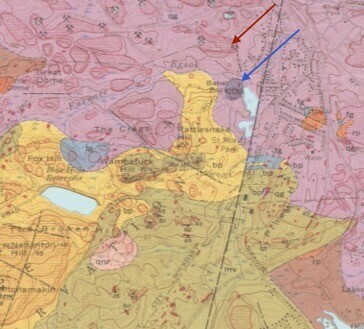
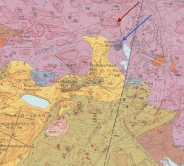
Where is Babel Rock?
The #USGS #BlueHills #quad #bedrock map and a #Quincy #Massachusetts #historical #map show Babel Rock overlooks a pond from just north of a bend in #Wampatuck Rd. I have been on that rock, and it's #diabase, a #mafic #intrusion into the Quincy #pluton. But the USGS #topographic quad & derivatives e.g. #GoogleEarth show it adjacent to the #BunkerHill #quarry (source of the #granite for the monument in #Boston).
Should a correction be proposed to USGS? Advice welcomed.
#usgs #bluehills #quad #bedrock #quincy #massachusetts #historical #map #wampatuck #diabase #mafic #intrusion #Pluton #topographic #googleearth #bunkerhill #quarry #granite #boston

IBCSO · @ibcso
10 followers · 13 posts · Server masto.ai
Why is it useful to know how #deep the #ocean it looks like? #Ship #traffic is depending on the knowledge of #topographic maps. But it is also crucial for models and estimations, to know where water masses can follow the bottom structure. #Antarctic #waters are known to be the earths engine, keeping all the global currents in motion. Understanding circulation processes is crucial to understand climate and weather. Also, animals use structures for orientation, as habitats or feeding grounds.
#deep #ocean #ship #traffic #topographic #antarctic #waters
Familienforschung · @genealogy
96 followers · 279 posts · Server berlin.socialHow did the world, different countries and cities or a special region look like many years ago? The #Map Archive tries to answer this question with the help of old world maps, some historical world atlases as well as thousands of #topographic maps, hundreds of street maps, special maps and city maps, especially from Germany, Central Europe and the world, from 1730 on. Ideal for #genealogical research.
#map #topographic #Genealogical

GregCocks · @GregCocks
6 followers · 15 posts · Server techhub.social
Quality Assessment Of DEM Derived From Topographic Maps For Geomorphometric Purposes
--
https://doi.org/10.1515/geo-2019-0066 <-- shared paper
--
#GIS #spatial #mapping #DEM #LiDAR #qualityassessment #geomorphometry #SilesianUpland #topographic #remotesensing #geomorphology #geomorphometry #quantative #landsurface #hillshade #slope #QAQC #landform #drainage #hydrology #water #quality #digital
#gis #spatial #mapping #dem #lidar #qualityassessment #geomorphometry #silesianupland #topographic #remotesensing #geomorphology #quantative #landsurface #hillshade #slope #qaqc #landform #drainage #hydrology #water #quality #digital

EyeInHand · @eyeinhand
37 followers · 280 posts · Server fosstodon.org

infoDOCKET · @infodocket
21 followers · 29 posts · Server newsie.social
Building Digital Research Tools for Open Access to Canada’s Historical #Topographic #Maps and #Data & More News Headlines https://www.infodocket.com/2022/12/05/building-digital-research-tools-for-open-access-to-canadas-historical-topographic-maps-and-more-news-headlines/

Φίλιππος Retsinokinitoc · @Kalogi
13 followers · 92 posts · Server masto.ai
RT @eevriviades@twitter.com
Since 1940, Turkey has erased the original names of 12,700 villages and places … via @hawzhin_azeez@twitter.com
More info: https://en.m.wikipedia.org/wiki/Place_name_changes_in_Turkey
#Turkey #Türkiye #names #doctrine #Turkification #toponymy #topographic #identity #HIStory5 #OttomanEmpire https://twitter.com/hawzhin_azeez/status/1597525068778999809
🐦🔗: https://twitter.com/eevriviades/status/1597671982472253440
#turkey #turkiye #names #doctrine #turkification #toponymy #topographic #identity #history5 #ottomanempire