
Mark Stosberg · @markstos
294 followers · 732 posts · Server urbanists.social
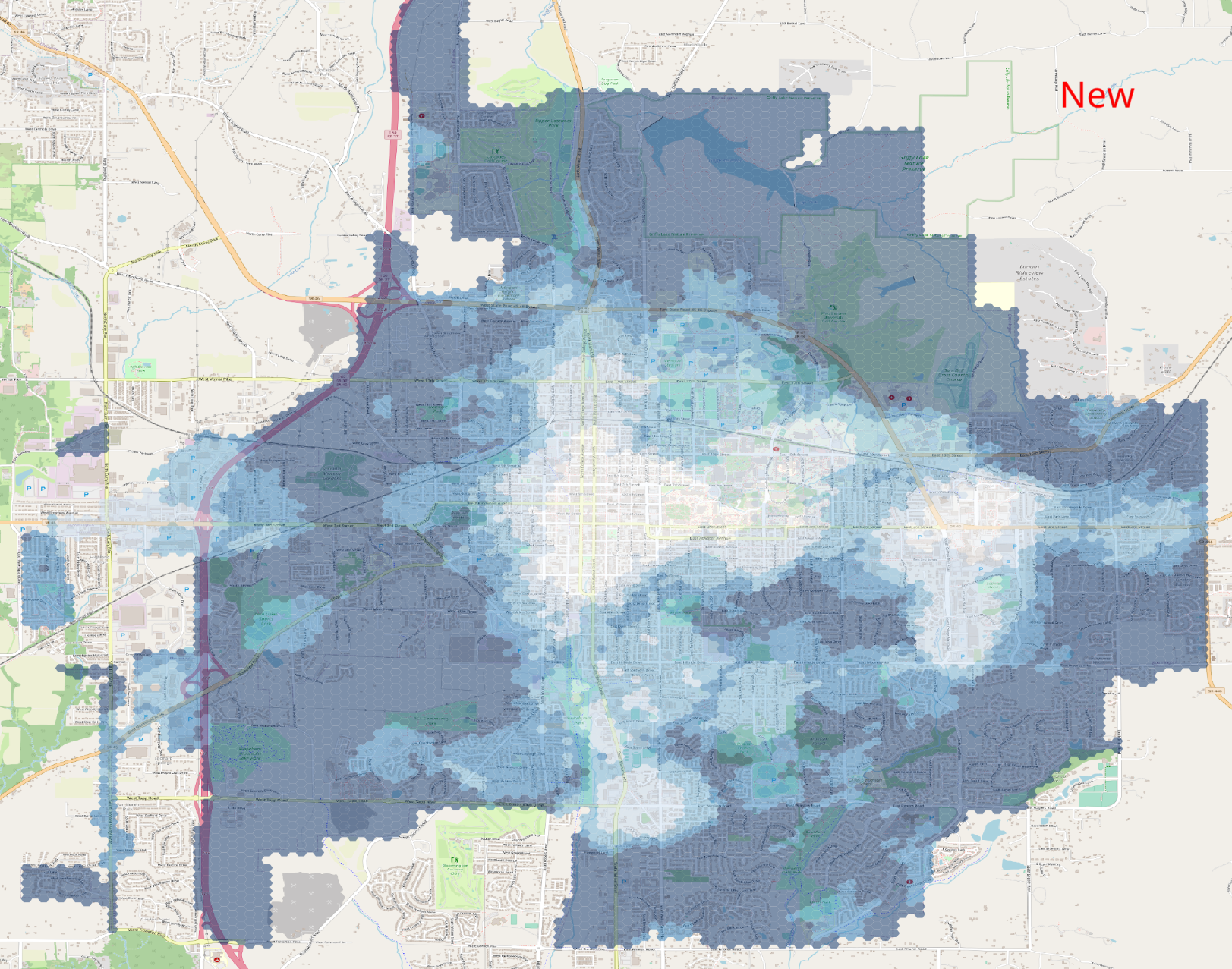
v3.0 of my "Walk Potential" software has been released. This an #UrbanPlanning #mapping tool used in planning to quantify the number of "interesting" places nearby to walk. Useful metric for demand to fix sidewalk network gaps.
Release notes: https://gitlab.com/markstos/walk-potential/-/releases/v3.0.0
Docs: https://gitlab.com/markstos/walk-potential/-/blob/main/README.md
First reply with a boundary polygon for their city wins free Walk Potential analysis for that city.
#gis #BloomingtonIN #OpenStreetMap #OpenTripPlanner #TurfJS
Example Walk Potential Heatmap:
#UrbanPlanning #mapping #gis #bloomingtonin #OpenStreetMap #opentripplanner #turfjs

Jeremia Kimelman · @jeremiak
254 followers · 132 posts · Server journa.hostAnd here's the list!
General use tools:
Web scraping tools
1. #p-queue
2. #cheerio
3. #puppeteer
Geospatial tools
1. #mapshaper
2. #turfjs
3. #qgis
Website tools
1. #sveltekit
Tools that are also companies
1. @observablehq
2. #Github actions
3. #netlify
#d3 #lodash #p #cheerio #puppeteer #mapshaper #turfjs #qgis #sveltekit #github #netlify
Jeremia Kimelman · @jeremiak
61 followers · 19 posts · Server journa.host
Wrote a TIL style post about turning a PNG into #GeoJSON.
The Forest Service publishes the results of their 10 hour dead fuel moisture model once a day as a PNG file with no geographic information, like the one attached to this post.
Sounds difficult. And turns out that it kind of is, _but_ also that the open source #geospatial tools are super powerful and you can totally do it too.
https://www.jeremiak.com/blog/extracting-fuel-moisture-data-from-rasters/
#geojson #geospatial #gdal #mapshaper #turfjs

Christian 👼 · @chringel
35 followers · 62 posts · Server fosstodon.orgNote to future self:
Use more #turfjs. It’s friggin' awesome!
Question to past self:
Why haven’t you been using more #turfjs? (https://chringel.dev/2022/09/06/0943/)

Olivier Duquesne aka DaffyDuke · @daffyduke
485 followers · 37712 posts · Server mamot.frRT @willy_maps
The closest 10 airports https://willymaps.github.io/spoke/ #builtwithmapbox #turfjs