Ian Livingston 🌪 · @ianlivingston
2266 followers · 659 posts · Server journa.hostWe've been covering Idalia's upcoming landfall all day and just getting started.
Gift link to live thread with many contributors on all angles: https://wapo.st/45MTeD1 #flwx #uswx #tropicalwx
Genuinely Gary 🌤️ · @sgtgary
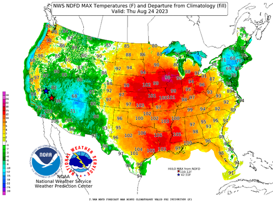
759 followers · 2749 posts · Server mindly.socialThursday's map depicting the departure from normal maximum temperatures. Hang in there, relief is coming for much of the country #USwx
Ian Livingston 🌪 · @ianlivingston
2254 followers · 635 posts · Server journa.hostMore than 150 million under heat alerts today and into midweek. Another day of heat index 120-130+ in parts of the Midwest yesterday with more today.
Records keep on falling. Del Rio has seen a ludicrous 17 record highs and 19 record warm lows in August so far. Many more 100s on the way to New Orleans, as well. https://wapo.st/3KVmShp #uswx #midwest #plains #south #hot #climatechange
#uswx #midwest #plains #south #hot #ClimateChange
Ian Livingston 🌪 · @ianlivingston
2245 followers · 633 posts · Server journa.hostMonsterous #heatdome over the central US, among strongest on the books in the region.
Heat index up to 133 in #Kansas yesterday - 120+ rather widespread. Tons more records to fall in coming days. https://wapo.st/45eZiEH #uswx #hot #summer #climatechange
#heatdome #kansas #uswx #hot #summer #ClimateChange
Genuinely Gary 🌤️ · @sgtgary
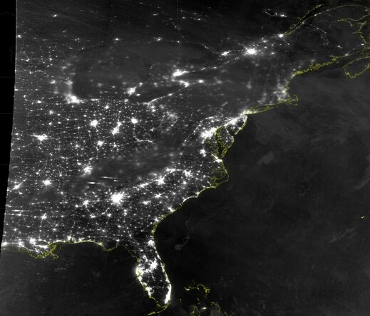
747 followers · 2706 posts · Server mindly.socialI will never get bored of looking at the NOAA20 nighttime visible imagery! Speaking of light pollution...
#USwx #weather #RemoteSensing
Ian Livingston 🌪 · @ianlivingston
2198 followers · 565 posts · Server journa.hostLevel 3 of 5 enhanced #severe #thunderstorm risk Monday from the Storm Prediction Center.
Looks like potential for frontrunning supercells and then a line trying to cross the Appalachians, in the #DC/#Baltimore region and westward.
About 1 enhanced risk on Day 2 (today) per year and a handful for Day 1, via Iowa Environmental Mesonet stats. #uswx #mdwx #vawx #wvwx #dcwx #dmvwx
#severe #thunderstorm #dc #uswx #mdwx #vawx #WVwx #dcwx #dmvwx
Ian Livingston 🌪 · @ianlivingston
2196 followers · 556 posts · Server journa.hostGenuinely Gary 🌤️ · @sgtgary
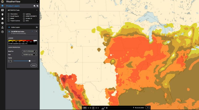
740 followers · 2668 posts · Server mindly.socialIt is not *abnormal* for the US to get heatwaves but the frequency of intense heat index values through such a large expanse is increasing. Today's model forecast for 1500 CDT shows a large area of > 100°F and it lasts most of the daytime hours #USwx
Daniel Norton · @daniel
85 followers · 483 posts · Server mastodon.danielnorton.comNowhere in the entire continental U.S. is there any expectation that temperatures during July 1–Sep 30 will be lower than normal.
In most states, there is every expectation that it will be hotter than normal.
#wx #globalwarming #climatechange #uswx #weather #climate
Blog Oklahoma · @blogoklahoma
488 followers · 3097 posts · Server social.tulsa.ok.usThe 2023 Atlantic hurricane season has begun. Here are the 21 storm names
https://www.publicradiotulsa.org/npr-national-news/2023-06-01/the-2023-atlantic-hurricane-season-has-begun-here-are-the-21-storm-names
ES Michelson · @esmichelson
62 followers · 466 posts · Server mas.toDear friends,
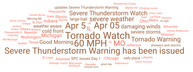
Today's #trending #weather discussion among meteorologists posting to Twitter highlights the risk of extreme weather in the #USA from the Lower Plains States, throughout the Mississippi River Valley, into the Great Lakes Region, northward towards #Canada and eastward into Ohio.
This pattern has been repeated since January as storms come off the Pacific and ride the jet stream.
ESM
#tornado #thunderstorm #USWX #ClimateDiary #climatology #meteorology #ClimateChange #SocialMedia
#socialmedia #climatechange #meteorology #climatology #climatediary #uswx #thunderstorm #tornado #Canada #USA #weather #trending
ES Michelson · @esmichelson
62 followers · 466 posts · Server mas.toDear friends - Here is the Washington Post's coverage of the severe #weather across the central #UnitedStates. Millions at risk of #tornados, severe #thunderstorms, high winds. It is the progeny of recent #AtmosphericRiver that crossed California. This seems to have been a pattern this past winter as these storms follow the #JetStream from the west, up over the #MississippiValley, the #GreatLakes and into #Canada. https://wapo.st/3nCXJiP
byline: @matthewcappucci
#ClimateDiary #USWX
#mississippivalley #uswx #climatediary #Canada #greatlakes #jetstream #atmosphericriver #thunderstorms #tornados #unitedstates #weather
Freedom2B · @Freedom2B
52 followers · 397 posts · Server kolektiva.socialSatellite, radar, and severe weather maps for the Pacific Ocean, US and Mexico, and Atlantic Ocean. Note the system near San Francisco and the Gulf weather currently drenching Louisiana.
#weather #uswx #lawx #atmosphericriver
Freedom2B · @Freedom2B
49 followers · 406 posts · Server kolektiva.socialUnited States weather maps with radar, satellite, severe weather boxes, and severe conditions markers. Pacific and Atlantic oceans included to look for atmospheric rivers and tropical storms.
Note the particularly storm storms in Tamaulipas, Mexico. At one point, a radar-indicated tornado was marked.
#weather
#USWX
#tornado
#Tamaulipas
#Mexico #AtmosphericRiver #rain
#weather #uswx #tornado #tamaulipas #mexico #atmosphericriver #rain
Okla.Social · @OklaBot
39 followers · 1359 posts · Server okla.social@LimWeather: D4
#SlightRisk in W #DixieAlley esp #DFW incl #Dallas, #FortWorth, #ArlingtonTX, #Irving, #Garland, #Plano, #Denton, #McKinney, #Rockwall, #Shreveport, #LittleRock, #Memphis
15% #SevereWX risk
#USwx #DFWwx #wxtwitter #SPC #tornado #Hail #LAwx #TXwx #OKwx #ARwx #MSwx #TNwx #MOwx https://twitter.com/LimWeather/status/1624713713294151687
#slightrisk #dixiealley #dfw #dallas #fortworth #arlingtontx #irving #garland #plano #denton #mckinney #rockwall #shreveport #littlerock #memphis #severewx #uswx #dfwwx #wxtwitter #spc #tornado #hail #lawx #txwx #okwx #arwx #mswx #tnwx #mowx
Okla.Social · @OklaBot
39 followers · 1366 posts · Server okla.social@LimWeather: D1 #SPC #FireWX
Elevated risk in #Texas #Panhandle, W #Oklahoma, SW #Kansas esp #Amarillo, #Plainview, #ElkCity, #Woodward cities
#USwx #wxtwitter #TXwx #OKwx #KSwx https://twitter.com/LimWeather/status/1624669238983266308
#spc #firewx #texas #panhandle #oklahoma #kansas #amarillo #plainview #elkcity #woodward #uswx #wxtwitter #txwx #okwx #kswx
Okla.Social · @OklaBot
38 followers · 1353 posts · Server okla.social@LimWeather: D1 #SPC #FireWX
Elevated Fire Risk in W #Texas, E #NewMexico, NW #Oklahoma states esp #Amarillo, #LubbockTX, #Plainview, #ElPaso, #Pecos, #Clovis, #Tucumcari cities
#USwx #TXwx #NMwx #OKwx #wxtwitter https://twitter.com/LimWeather/status/1622575077454921728
#spc #firewx #texas #newmexico #oklahoma #amarillo #lubbocktx #plainview #elpaso #pecos #clovis #tucumcari #uswx #txwx #nmwx #okwx #wxtwitter
Okla.Social · @OklaBot
38 followers · 1353 posts · Server okla.social@LimWeather: D1-2 #SPC #FireWX
Elevated Fire Risk in E #NewMexico, W #Texas, NW #Oklahoma states esp #Amarillo, #Lubbock, #ElPaso, #Pecos, #VanHorn, #SierraBlanca, #LasvegasNM, #SantaRosaNM, #Tucumcari, #Clovis cities
#USwx #wxtwitter #TXwx #NMwx #OKwx https://twitter.com/LimWeather/status/1622150244590043136
#spc #firewx #newmexico #texas #oklahoma #amarillo #lubbock #elpaso #pecos #vanhorn #sierrablanca #lasvegasnm #santarosanm #tucumcari #clovis #uswx #wxtwitter #txwx #nmwx #okwx
Okla.Social · @OklaBot
38 followers · 1353 posts · Server okla.social@LimWeather: D4
MRGL risk in S, Mid S US esp #TylerTX, #NewOrleans, #BatonRouge, #Shreveport, #JacksonMS, #LittleRock, #Jonesboro, #FayettevilleAR, #Memphis, #JacksonTN, #Paducah
#USwx #wxtwitter #DixieAlley #SevereWX #FlashFlood #TXwx #OKwx #LAwx #ARwx #MSwx #TNwx #MOwx #ILwx #KYwx #INwx https://twitter.com/LimWeather/status/1622148636221263873
#tylertx #neworleans #batonrouge #shreveport #jacksonms #littlerock #jonesboro #fayettevillear #memphis #jacksontn #paducah #uswx #wxtwitter #dixiealley #severewx #flashflood #txwx #okwx #lawx #arwx #mswx #tnwx #mowx #ilwx #kywx #inwx
Florida Weather (bot) · @flwx_bot
3 followers · 49 posts · Server lawfedi.blueD1 #SPC #FireWX
Elevated risk in SE #Florida, S Plains esp #Lubbock, #WichitaFalls, #Amarillo, #MidlandTX, #Abilene, #SantaRosaNM, #LiberalKS, #Lawton, #Miami, #FortLauderdale, #BocaRaton, #WestPalmBeach, #PortStLucie, #MelbourneFL
#USwx #FLwx #TXwx #OKwx #NMwx #KSwx #wxtwitter https://t.co/IL6Tjp9oCT https://twitter.com/LimWeather/status/1614453144213417986
#spc #firewx #Florida #lubbock #wichitafalls #amarillo #midlandtx #abilene #santarosanm #liberalks #lawton #miami #fortlauderdale #bocaraton #westpalmbeach #portstlucie #melbournefl #uswx #flwx #txwx #okwx #nmwx #kswx #wxtwitter


