
Matthew Bandy · @inti
153 followers · 146 posts · Server archaeo.social
#archaeology #landscape #visualization from #lidar - 16th in a series, and my 13th post on #ChacoanBeltRoads.
Like the last one, this belt road is on #UteMountainUte tribal lands in #Colorado. This one is a little unusual because while it is located in the center of a large cluster of smaller sites, there is no single large site directly associated with the feature itself.
Second observation: these are probably not "roads" in any utilitarian sense.
#archaeology #landscape #visualization #lidar #chacoanbeltroads #utemountainute #colorado #archaeologylandscapevisualization
Matthew Bandy · @inti
148 followers · 137 posts · Server archaeo.social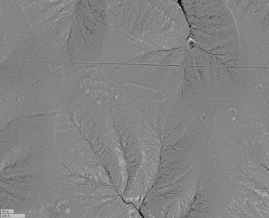
#archaeology #landscape #visualization from #lidar - 15th in a series, and my 12th post on #ChacoanBeltRoads.
This belt road is on #UteMountainUte tribal lands as as far as I know has never been documented.
We're approaching the end of this series on, so perhaps now it is time to ask the question - what are these things? The first observation we can make is that they are not pan-Chacoan. No belt roads have been found on sites in #ChacoCanyon itself
#archaeology #landscape #visualization #lidar #chacoanbeltroads #utemountainute #chacocanyon #archaeologylandscapevisualization
Matthew Bandy · @inti
147 followers · 136 posts · Server archaeo.social
#archaeology #landscape #visualization from #lidar - 14th in a series, and my 11th post on #ChacoanBeltRoads.
This is belt road is also on #MesaVerde but not on the National Park. It is on #UteMountainUte tribal lands. Note the road leading t the southeast from the architectural block at the center of the loop. The loop is mostly in pinyon/juniper woodland and is not visible at all in aerial imagery.
#archaeology #landscape #visualization #lidar #chacoanbeltroads #mesaverde #utemountainute