
GregCocks · @GregCocks
598 followers · 534 posts · Server techhub.social
National Park Services (NPS) ‘Park Tiles’ [public web mapping, USA]
--
https://www.nps.gov/maps/tools/park-tiles/index.html#12/38.5640/-107.6372 <-- entry point
--
H/T @james McAndrew + @jake Coolidge
[also a mobile app ]
“Park Tiles is a suite of online basemaps designed to fit the National Park Service’s graphic identity. Built with simplicity and flexibility in mind, Park Tiles basemaps can be used as stand-alone reference maps, or customized web maps with additional data overlays. Park Tiles features NPS-sourced data inside park boundaries, and relies on OpenStreetMap data to provide additional context…”
#GIS #spatial #mapping #PostGIS #PostgresSQL #QGIS #vectortiles #opendata #opensource #gischat #ParkTiles #OSM #basemaps #NPS #maps #webmaps
@NPS
#gis #spatial #mapping #postgis #postgressql #qgis #vectortiles #opendata #opensource #gischat #parktiles #osm #basemaps #nps #Maps #webmaps

BNHR.XYZ :tux: :qgis: · @bnhrdotxyz
55 followers · 42 posts · Server fosstodon.orgHow about you, what are you most excited about in QGIS 3.32?
You can read the changelog at https://changelog.qgis.org/en/qgis/version/3.32/ or watch it at https://www.youtube.com/watch?v=ZtE1Az-zpf0
#QGIS #GIS #FOSS #FOSS4G #GISChat #PointCloud #Lidar #VectorTiles
#qgis #gis #foss #foss4g #gischat #pointcloud #lidar #vectortiles
BNHR.XYZ :tux: :qgis: · @bnhrdotxyz
55 followers · 42 posts · Server fosstodon.orgThis feature was developed through a joint crowdfunding campaign by Lutra Consulting, North Road, and Hobu with the help of the community (BNHR being one of the many supporters of this crowdfunding campaign).
Other notable features in this release include:
- Map tip previews
- Annotation improvements
- Links in map exports
- Download vector tiles algorithm
- User profile selector
- Thread management in algorithm settings
#QGIS #GIS #FOSS #FOSS4G #GISChat #PointCloud #Lidar #VectorTiles
#qgis #gis #foss #foss4g #gischat #pointcloud #lidar #vectortiles

astrid · @astrid
87 followers · 140 posts · Server fimidi.com#SelfMade and #SelfHosted #VectorTiles on the #website of a small village: 338 objects with a total size of 560.2 kB.
#selfmade #selfhosted #vectortiles #website #openstreetmap #opendata #cms #joomla
MapTheClouds · @maptheclouds
77 followers · 16 posts · Server mapstodon.spaceCity Tiles 🌆
#D3js #Nextzen #OSMBuildings #VectorTiles #maps #buildings #romania #maptheclouds #travel #cartography #arts #perspective #design #motiongraphics #cgi #timisoara #bucuresti #clujnapoca #brasov
#d3js #nextzen #osmbuildings #vectortiles #maps #Buildings #Romania #maptheclouds #travel #cartography #arts #perspective #design #motiongraphics #cgi #timisoara #bucuresti #clujnapoca #brasov

Jorge · @xurxosanz
545 followers · 447 posts · Server mastodon.socialNuevo servicio de teselas vectoriales de la Base Topográfica Nacional (BTN)
https://buff.ly/3krsLbY

Raf · @Raf
298 followers · 5913 posts · Server mastodon.social
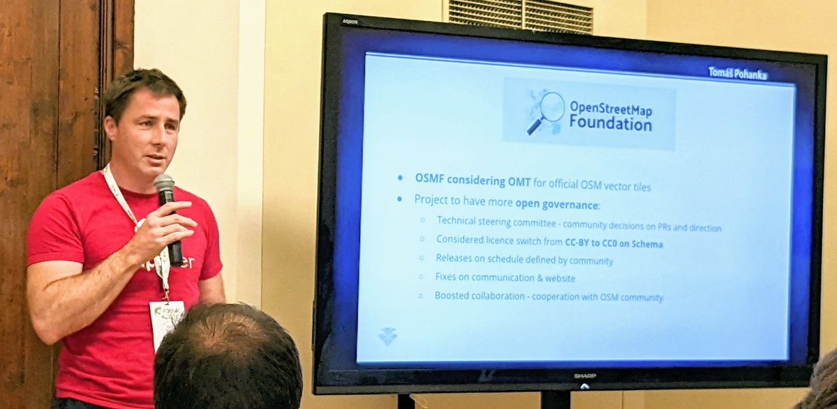
RT @OpenMapTiles@twitter.com
Just Announced📢 OpenMapTiles makes steps towards Open Governance and considers CC0 licence!
OpenMapTiles may also become the Official #OSM #VectorTiles!!
#FOSS4G2022 @openstreetmap@twitter.com @foss4g@twitter.com
🐦🔗: https://twitter.com/OpenMapTiles/status/1563106235469115392

Christian 👼 · @chringel
35 followers · 62 posts · Server fosstodon.org
Christian 👼 · @chringel
35 followers · 62 posts · Server fosstodon.orgJust generated #openstreetmap #vectortiles from a planet file using #planetiler on an #azure vm.
It only took roughly 2.5 hours. That's amazing 🤯
#openstreetmap #vectortiles #Planetiler #azure
Christian 👼 · @chringel
35 followers · 62 posts · Server fosstodon.orgI'm currently working on a #google #maps clone for a small #spatial extent.
Backend:
* #vectortiles created using #planetiler, served by #tileservergl
* Routing through #graphhopper
* Geocoding through #komoot #photon, data from #openstreetmap
Frontend:
* #react and @mapcomponents
Just a #sideproject. Let's see how far I'll get in 2 days.
#google #maps #spatial #vectortiles #Planetiler #tileservergl #graphhopper #komoot #photon #openstreetmap #react #sideproject
Raf · @Raf
298 followers · 5913 posts · Server mastodon.social
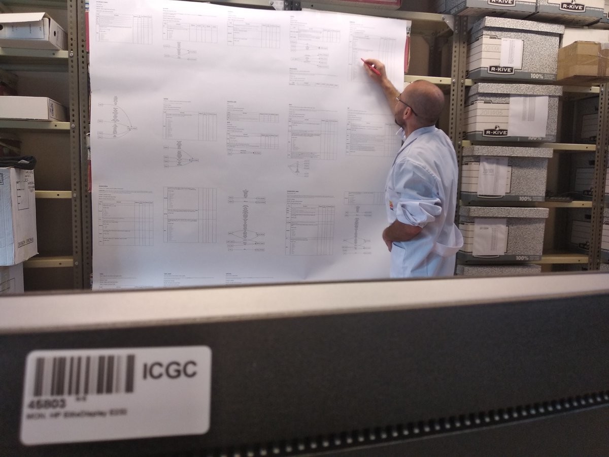
RT @ICGCGeostarters@twitter.com
Dr. @bolosig@twitter.com trabajando en el encaje del esquema @OpenMapTiles@twitter.com con los datos del @ICGCat@twitter.com para la base #contextmaps en formato #vectortiles.
🐦🔗: https://twitter.com/ICGCGeostarters/status/1113060426390986753
Raf · @Raf
298 followers · 5913 posts · Server mastodon.socialRT @BNiene@twitter.com
The power of Vector Tiles! Need reading glasses? >> Or increase the font size of all text layers :) @cartiqomaps@twitter.com #vectortiles @webmappery@twitter.com
Raf · @Raf
298 followers · 5913 posts · Server mastodon.socialRT @ICGCGeostarters@twitter.com: Testing the new possibilities of #MapboxGL to include 3D models over our basemaps. Awesome! Lots of ideas come to us! @sagradafamilia@twitter.com
https://openicgc.github.io/icgc-model3d.html
@Mapbox@twitter.com @ericg@twitter.com #vectortiles #3D
http://betaportal.icgc.cat
🐦🔗: https://twitter.com/ICGCGeostarters/status/1063437326980911105
Raf · @Raf
298 followers · 5913 posts · Server mastodon.socialRT @ibesora@twitter.com: A data-driven journey through Vector Tile optimization #VectorTiles #VectorMaps #mapbox #GIS https://link.medium.com/LOzniU7dpR
#vectormaps #mapbox #gis #vectortiles
Raf · @Raf
298 followers · 5913 posts · Server mastodon.social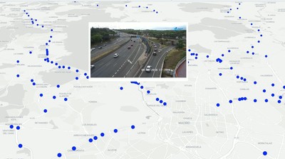
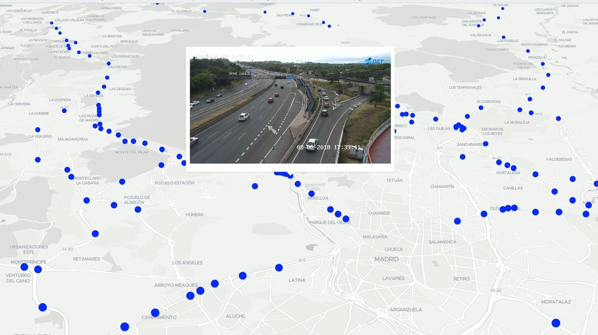
RT @geomati_co@twitter.com: Nos hemos puesto creativos en el taller de DATEX y hemos hecho un mapa con #VectorTiles para ver las cámaras de tráfico en tiempo real #siglibre2018 http://geomati.co/DATEX/viewer/#11.83/40.45872/-3.75365/-8.8/58
🐦🔗: https://twitter.com/geomati_co/status/1005114830569787393