
Joseph Elfelt · @mappingsupport
504 followers · 433 posts · Server m.ai6yr.org
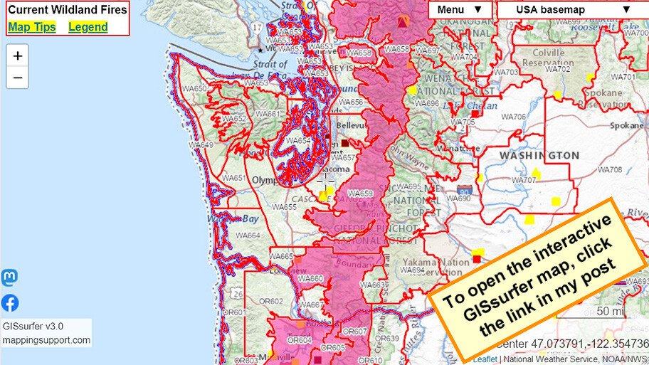
#RedFlagWarning includes *west* slopes of Cascade Mountains.
For details - including timing - open the map, zoom in, click your area of interest, follow the link.
Click “Map tips” upper left corner for more info.
#PNW #WAfire #WAwx #ORfire #ORwx #CAfire #CAwx #Wildfire #GIS
Open #GISsurfer map:
https://mappingsupport.com/p2/gissurfer.php?center=44.237006,-122.563477&zoom=6&basemap=USA_basemap&overlay=State_boundary,Weather_watch_warning&data=https://mappingsupport.com/p2/special_maps/disaster/USA_weather.txt
#redflagwarning #pnw #wafire #wawx #orfire #orwx #cafire #cawx #Wildfire #gis #gissurfer
Joseph Elfelt · @mappingsupport
480 followers · 412 posts · Server m.ai6yr.org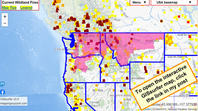
#RedFlagWarning includes *west* slopes of Cascade Mountains.
For details open the map, zoom in, click your area of interest, follow the link.
Click “Map tips” upper left corner for more info.
#PNW #WAfire #WAwx #ORfire #ORwx #IDfire #IDwx #MTfire #MTwx #Wildfire #GIS
Open #GISsurfer map:
https://mappingsupport.com/p2/gissurfer.php?center=46.148533,-115.048828&zoom=5&basemap=USA_basemap&overlay=VIIRS_7_day,MODIS_7_day,State_boundary,Red_flag_warning&data=https://mappingsupport.com/p2/special_maps/disaster/USA_wildland_fire.txt
#redflagwarning #pnw #wafire #wawx #orfire #orwx #idfire #idwx #mtfire #mtwx #Wildfire #gis #gissurfer
Joseph Elfelt · @mappingsupport
480 followers · 411 posts · Server m.ai6yr.org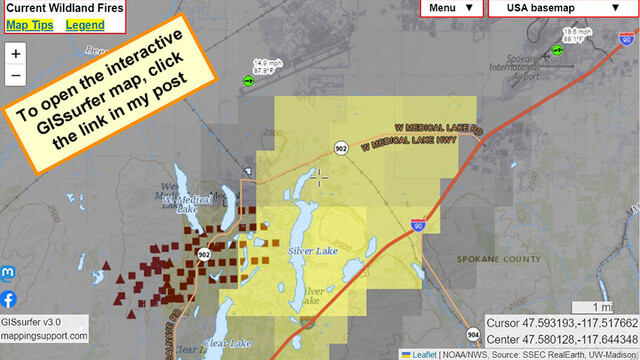
Latest satellite heat detections for #GrayFire Spokane County, WA. Large yellow squares are detections by GOES satellite. Some of that data is likely smoke but not fire on the ground - at least yet.
Never rely on any map to ignore an order to evacuate.
I-90 closed in both directions.
Green symbols are clickable for weather data including wind gust speed. #WAfire #WAwx #Wildfire
Open #GISsurfer map:
https://mappingsupport.com/p2/gissurfer.php?center=47.580128,-117.644348&zoom=12&basemap=USA_basemap&overlay=State_boundary,MODIS_7_day,VIIRS_7_day,GOES_west_fire_enhanced,Lake_river_stream,USA_roads,Wind_temperature_and_more...&data=https://mappingsupport.com/p2/special_maps/disaster/USA_wildland_fire.txt
#grayfire #wafire #wawx #Wildfire #gissurfer
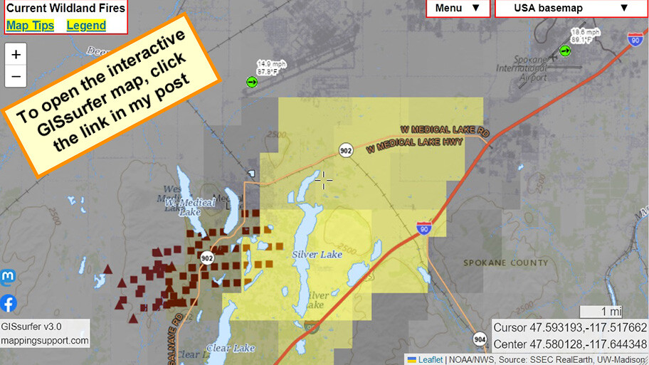
Joseph Elfelt · @mappingsupport
479 followers · 410 posts · Server m.ai6yr.org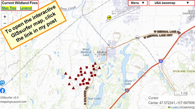
Interactive #GIS map for #GrayFire Spokane County, WA. Town of #MedicalLake (pop 5,000+) ordered to evacuate *now*.
Weather station at airport just to the north shows WSW wind gusting to 31mph. I see reports fire has already jumped the lake on the west side of town.
To get the most benefit from the map see 2 links upper left corner.
#WAfire #WAwx #Wildfire #GIS #Geospatial #Maps #Mapping #Leaflet #ArcGIS #WebMap
Open #GISsurfer map:
https://mappingsupport.com/p2/gissurfer.php?center=47.568592,-117.688465&zoom=13&basemap=USA_imagery&overlay=State_boundary,USA_roads,MODIS_7_day,VIIRS_7_day,Fire_perimeter_NIFC&data=https://mappingsupport.com/p2/special_maps/disaster/USA_wildland_fire.txt
#gis #grayfire #medicallake #wafire #wawx #Wildfire #geospatial #maps #mapping #leaflet #arcgis #webmap #gissurfer
Joseph Elfelt · @mappingsupport
472 followers · 395 posts · Server m.ai6yr.org
#PacificCrestTrail is closed in northern WA due to the #BlueLakeFire east of Rainey Pass.
To get the most benefit from the map see 2 links upper left corner.
#PCT #WAfire #WAwx.
Open #GISsurfer map:
https://mappingsupport.com/p2/gissurfer.php?center=48.496455,-120.688591&zoom=13&basemap=USA_basemap&overlay=VIIRS_7_day,MODIS_7_day,State_boundary,Fire_perimeter_NIFC&data=https://mappingsupport.com/p2/special_maps/disaster/USA_wildland_fire.txt
#pacificcresttrail #bluelakefire #pct #wafire #wawx #gissurfer
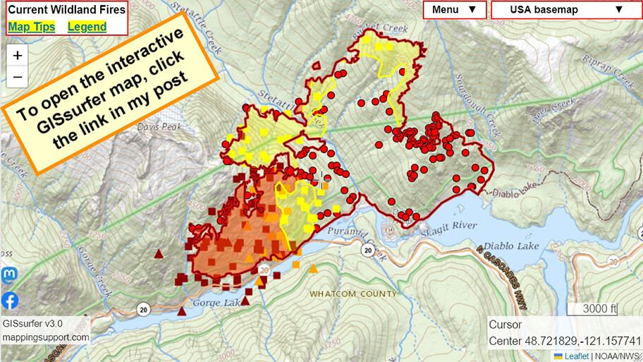
Joseph Elfelt · @mappingsupport
464 followers · 382 posts · Server m.ai6yr.org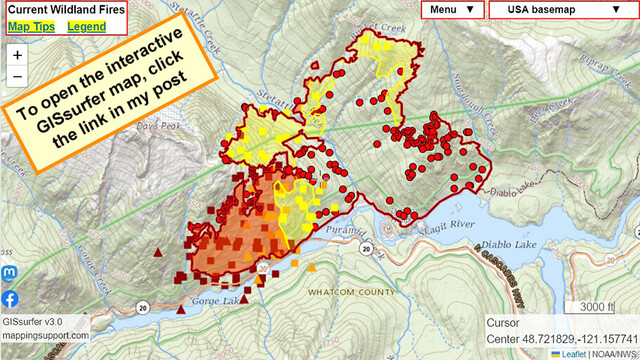
August 13 morning. #SourdoughFire, Diablo WA.
Infrared flight last night 8:52pm. IR analyst determined 2,586 acres burned.
#RedFlagWarning until Tuesday evening.
Highway 20 is closed.
See “Map tips” and “Legend” links in upper left corner.
#WAwx #WAfire #Wildfire #GIS #Geospatial #Maps #Mapping #Leaflet #ArcGIS #WebMap
Open #GISsurfer map:
https://mappingsupport.com/p2/gissurfer.php?center=48.721829,-121.157741&zoom=13&basemap=USA_basemap&overlay=VIIRS_7_day,MODIS_7_day,State_boundary,USA_roads&fire=WA,Sourdough&data=https://mappingsupport.com/p2/special_maps/disaster/USA_wildland_fire.txt
#sourdoughfire #redflagwarning #wawx #wafire #Wildfire #gis #geospatial #maps #mapping #leaflet #arcgis #webmap #gissurfer
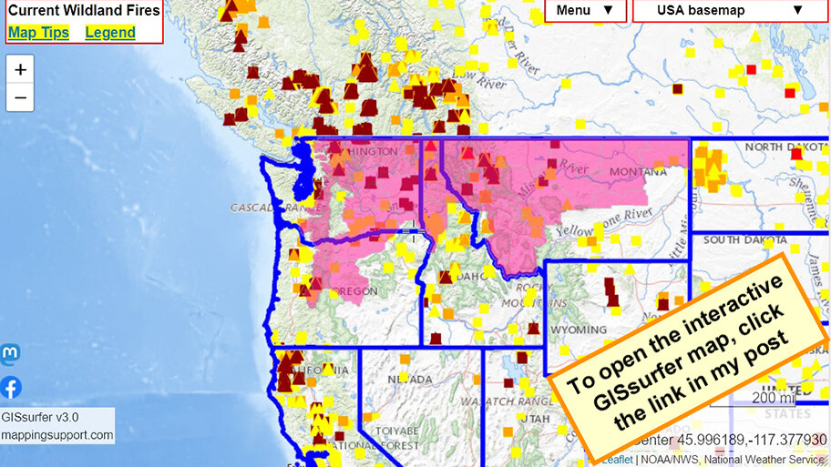
Joseph Elfelt · @mappingsupport
459 followers · 373 posts · Server m.ai6yr.org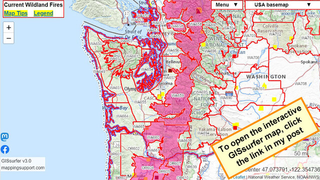
#RedFlagWarning for *west* slopes of Cascade Mountains. Typically, this is the soggy side, but not now.
To read NOAA’s “fire weather forecast” open the map, click in any red-outlined zone and follow the link.
Map has *lots* of fire related layers you can turn on/off. Click “Map tips” upper left corner for help.
#PNW #WAfire #WAwx #ORfire #ORwx #Wildfire #Geospatial #Maps #Mapping #Leaflet #ArcGIS #WebMap
Open #GISsurfer map:
https://mappingsupport.com/p2/gissurfer.php?center=47.604368,-121.854858&zoom=8&basemap=USA_basemap&overlay=VIIRS_7_day,MODIS_7_day,State_boundary,Red_flag_warning,NOAA_fire_weather_forecast&data=https://mappingsupport.com/p2/special_maps/disaster/USA_wildland_fire.txt
#redflagwarning #pnw #wafire #wawx #orfire #orwx #Wildfire #geospatial #maps #mapping #leaflet #arcgis #webmap #gissurfer
Joseph Elfelt · @mappingsupport
431 followers · 327 posts · Server m.ai6yr.org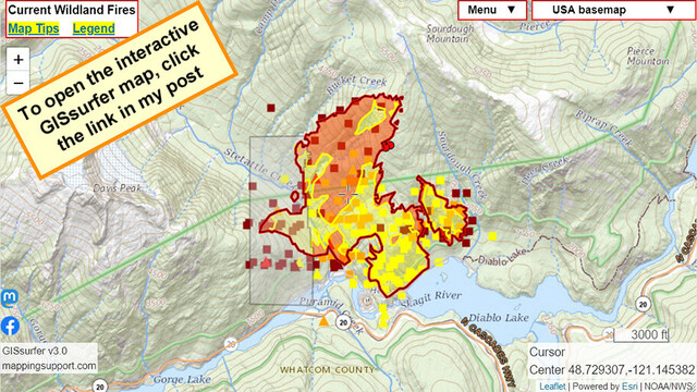
August 5 morning. #SourdoughFire, Diablo WA.
Infrared flight last night 8:17pm. IR analyst determined 1,176 acres burned. However, analyst was not able to fully review area shaded white on the map.
Highway 20 (North Cascades Highway) is currently closed.
Fire is now in North Cascades National Park. This area has not burned in well over 20 years.
#WAwx #WAfire #Wildfire #GIS #Geospatial #Maps #Mapping #Leaflet #ArcGIS #WebMap
Open #GISsurfer map:
https://mappingsupport.com/p2/gissurfer.php?center=48.729307,-121.145382&zoom=13&basemap=USA_basemap&overlay=VIIRS_7_day,MODIS_7_day,State_boundary,USA_roads&fire=WA,Sourdough&data=https://mappingsupport.com/p2/special_maps/disaster/USA_wildland_fire.txt
#sourdoughfire #wawx #wafire #Wildfire #gis #geospatial #maps #mapping #leaflet #arcgis #webmap #gissurfer

Kit · @Scatterseed
268 followers · 506 posts · Server alaskan.social
Every summer a place I love burns. Every winter a place I love crumbles into the sea. #SourdoughFire #WAFire
Joseph Elfelt · @mappingsupport
418 followers · 315 posts · Server m.ai6yr.org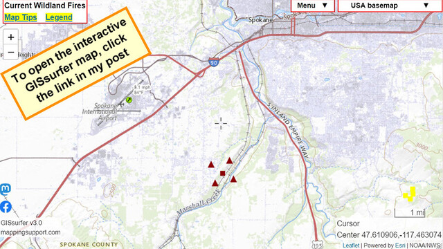
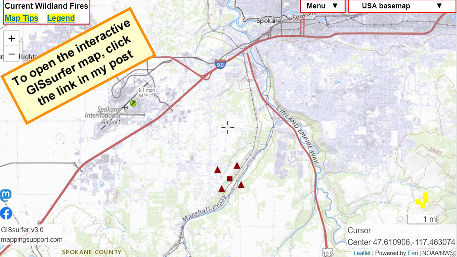
July 31 afternoon. Interactive #GIS map shows satellite *heat* detection for #WestHalletFire south side of Spokane WA.
Some heat detections are likely smoke in the air but not fire on the ground. But with that said, never rely on any map to ignore an order to evacuate.
Please read the “Map tips” link and “Legend” in upper left corner.
#WAfire #WAwx #wildfire #Geospatial #Maps #Mapping #Leaflet #ArcGIS #WebMap
Open #GISsurfer map:
https://mappingsupport.com/p2/gissurfer.php?center=47.610906,-117.463074&zoom=12&basemap=USA_basemap&overlay=VIIRS_7_day,MODIS_7_day,State_boundary,Wind_temperature_and_more...&data=https://mappingsupport.com/p2/special_maps/disaster/USA_wildland_fire.txt
#gis #westhalletfire #wafire #wawx #Wildfire #geospatial #maps #mapping #leaflet #arcgis #webmap #gissurfer
Joseph Elfelt · @mappingsupport
417 followers · 307 posts · Server m.ai6yr.org
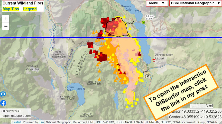
July 31 morning. Interactive #GIS map shows MODIS and VIIRS satellite *heat* detection for #EagleBluffFire near #Oroville WA and #Osoyoos BC.
Apparently no infrared flight last night.
Pink area on USA side is clickable and at time of my post shows 9,743 acres as of Saturday evening.
#WAfire #WAwx #BCfire #wildfire #Geospatial #Maps #Mapping #Leaflet #ArcGIS #WebMap
Open #GISsurfer map: https://bit.ly/43OfN8X
#gis #eagleblufffire #oroville #osoyoos #wafire #wawx #bcfire #Wildfire #geospatial #maps #mapping #leaflet #arcgis #webmap #gissurfer
Joseph Elfelt · @mappingsupport
417 followers · 307 posts · Server m.ai6yr.org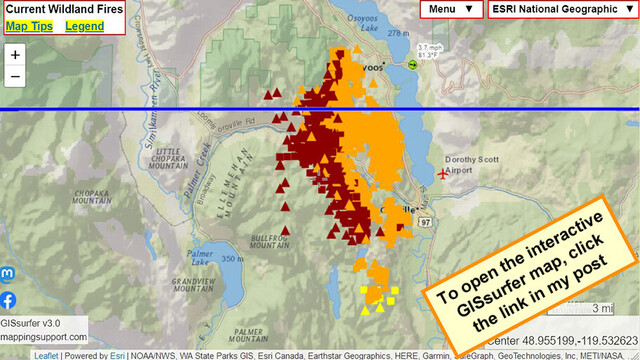
July 30 evening. Interactive #GIS map shows MODIS and VIIRS satellite *heat* detection for #EagleBluffFire near #Oroville WA and #Osoyoos BC.
If there is an infrared flight tonight then I will post a map with that data early tomorrow.
#WAfire #WAwx #BCfire #wildfire #Geospatial #Maps #Mapping #Leaflet #ArcGIS #WebMap
Open #GISsurfer map:
https://mappingsupport.com/p2/gissurfer.php?center=48.955199,-119.532623&zoom=11&basemap=ESRI_National_Geographic&overlay=VIIRS_7_day,MODIS_7_day,State_boundary,Wind_temperature_and_more...&data=https://mappingsupport.com/p2/special_maps/disaster/USA_wildland_fire.txt
#gis #eagleblufffire #oroville #osoyoos #wafire #wawx #bcfire #Wildfire #geospatial #maps #mapping #leaflet #arcgis #webmap #gissurfer
Joseph Elfelt · @mappingsupport
413 followers · 301 posts · Server m.ai6yr.org
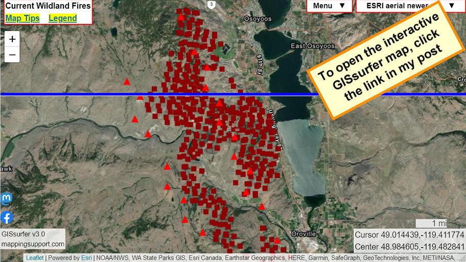
July 30 morning. Interactive #GIS map shows MODIS and VIIRS satellite *heat* detection for #EagleBluffFire near #Oroville WA and #Osoyoos BC.
Detection data is not real time, locations only approximate and sometimes ‘false positive’. To learn more, click “Map tips” in upper left corner and read about MODIS/VIIRS.
#WAfire #WAwx #BCfire #wildfire #Geospatial #Maps #Mapping #Leaflet #ArcGIS #WebMap
Open #GISsurfer map:
https://mappingsupport.com/p2/gissurfer.php?center=48.984605,-119.482841&zoom=12&basemap=ESRI_aerial_newer&overlay=VIIRS_7_day,MODIS_7_day,State_boundary&data=https://mappingsupport.com/p2/special_maps/disaster/USA_wildland_fire.txt
#gis #eagleblufffire #oroville #osoyoos #wafire #wawx #bcfire #Wildfire #geospatial #maps #mapping #leaflet #arcgis #webmap #gissurfer

MappingSupport · @mappingsupport
3 followers · 6 posts · Server mapstodon.space
July 23 morning. #NewellRoadFire 17+ miles east of Goldendale WA. #Klickitat County
#RedFlagWarning today. West wind 20 to 30 mph with gusts up to 35 mph.
Pink shading is the area that has burned as of yesterday. See 2 links upper left corner.
#WAfire #WAwx #wildfire #GIS #Geospatial #Maps #Mapping #Leaflet #ArcGIS #WebMap #PNW
Open #GISsurfer map: https://bit.ly/450yffL
#newellroadfire #klickitat #redflagwarning #wafire #wawx #wildfire #GIS #geospatial #maps #mapping #leaflet #arcgis #webmap #pnw #gissurfer
Kit · @Scatterseed
238 followers · 182 posts · Server alaskan.social
Mason County Sheriff's Office says updates will be available soon. #McEwanFire #Shelton #WAFire
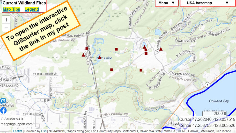
Joseph Elfelt · @mappingsupport
253 followers · 161 posts · Server m.ai6yr.org
July 4 evening. #McEwanFire a few miles NE of Shelton Washington. Evacuations underway.
When map opens it shows heat detections from MODIS and VIIRS satellites. That data not real time, locations only approximate and sometimes ‘false positive’. To learn more click “Map tips” upper left corner. #PNW #WAfire #WAwx #Wildfire
Open #GISsurfer map:
https://mappingsupport.com/p2/gissurfer.php?center=47.258753,-123.063526&zoom=14&basemap=USA_basemap&overlay=State_boundary,Wildland_fire_name,USA_roads,MODIS_7_day,VIIRS_7_day&data=https://mappingsupport.com/p2/special_maps/disaster/USA_wildland_fire.txt
#mcewanfire #pnw #wafire #wawx #Wildfire #gissurfer

Mark Ingalls :pdx_badge: · @ingalls
1451 followers · 4946 posts · Server pdx.social
Joseph Elfelt · @mappingsupport
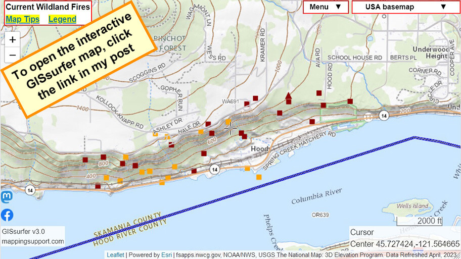
227 followers · 146 posts · Server m.ai6yr.org
July 3. #Tunnel5Fire near Underwood WA. Map shows MODIS/VIIRS satellite heat detection.
To read the fire weather forecast, open the map, click the map, scroll down in the data that appears and then follow the link.
The map has lots of #GIS fire related layers you can turn on/off/restack. The ‘top’ layer can be clicked to see attribute data. Need help? See 2 links upper left corner of the map. #WAfire #WAwx #Geospatial #ArcGIS #Leaflet
Open #GISsurfer map:
https://mappingsupport.com/p2/gissurfer.php?center=45.727244,-121.571102&zoom=14&basemap=USA_basemap&overlay=State_boundary,Wildland_fire_name,USA_main_contour_lines,MODIS_7_day,VIIRS_7_day,USA_roads,NOAA_fire_weather_forecast&data=https://mappingsupport.com/p2/special_maps/disaster/USA_wildland_fire.txt
#tunnel5fire #gis #wafire #wawx #geospatial #arcgis #leaflet #gissurfer
Joseph Elfelt · @mappingsupport
203 followers · 142 posts · Server m.ai6yr.org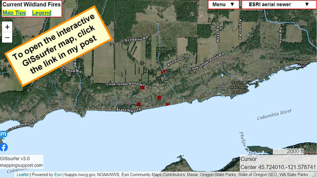
#Tunnel5Fire near Underwood WA, Skamania County.
Map shows first satellite heat detections. That data is not real time, locations are only approximate and sometimes ‘false positive’. To learn more about the limitations of the this data click “Map tips” link in upper left corner and read about MODIS and VIIRS. #WAfire #WAwx
Open #GISsurfer map:
https://mappingsupport.com/p2/gissurfer.php?center=45.724010,-121.578741&zoom=14&basemap=ESRI_aerial_newer&overlay=VIIRS_7_day,MODIS_7_day,State_boundary,Wildland_fire_name,Lake_river_stream&data=https://mappingsupport.com/p2/special_maps/disaster/USA_wildland_fire.txt
#tunnel5fire #wafire #wawx #gissurfer