
Juan · @romeroabelleira
3 followers · 22 posts · Server ruby.social#introduction Hola 👋🏽 I was on MySpace in 2005, studiVZ in 2006, FB in 2007, and Twitter in 2009, which means I’m old.
I’m a trained software #dev and I make a living coding a #rubyonrails #webgis for @GeoKtZH, building on the shoulders of giants and hoping they don’t mind. I used to play a bunch of single-player #crpg games, but now I’m a dad and so BG3 will have to wait.
I would tell you more, but I have boundaries.
#introduction #dev #rubyonrails #webgis #crpg

Niklas Alt · @oshistory
40 followers · 6 posts · Server fedihum.orgIn a recent side project from my job at the HIL I used Cloud Optimized GeoTIFFs #cog for the first time in production. Amazing to see the native handling by #openlayers Once i figure out how to use the associated HTTP requests for monitoring and controlling i will migrate more of our #webgis applications. The progressive web app locates places of historically green spaces in #Fulda 👇
https://www.lagis-hessen.de/maps/gruen-in-fulda/map
#cog #openlayers #webgis #Fulda

MapComponents · @mapcomponents
16 followers · 24 posts · Server fosstodon.org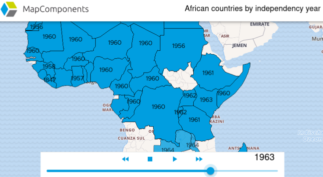
After a consolidating phase, we continue with exciting new features. Among other things, a component was completed, which enables a great visualization of data with temporal changes: https://catalogue.mapcomponents.org/en/component-detail/MlTemporalController
The instructions can be found here: https://mapcomponents.github.io/react-map-components-maplibre/?path=/story/mapcomponents-mltemporalcontroller--fill-config
#newfeature #temporaldata #opensource #webgis #mapcomponents #react #github
#newfeature #temporaldata #opensource #webgis #mapcomponents #react #github

Anita Graser 🇪🇺🇺🇦 · @underdarkGIS
2367 followers · 1717 posts · Server fosstodon.org@rony follow the related hashtags, e.g. #webgis #gischat #openlayers #leaflet and follow the accounts you discover there
#webgis #gischat #openlayers #leaflet
MapComponents · @mapcomponents
14 followers · 19 posts · Server fosstodon.org
Today at 6:15 p.m. there will be a lecture entitled "MapComponents - the WebGIS construction kit one year later" in the "B28: Innovation Forum: Solutions & Services" block at the #GISalzburg23 in the Blauer Hörsaal.
#GISalzburg23 #opensource #webgis #mapcomponents #salzburg
MapComponents · @mapcomponents
13 followers · 17 posts · Server fosstodon.org
there will be a MapComponents presentation at the fair "GI Salzburg" -> https://www.conftool.com/gi-salzburg2023/index.php?page=browseSessions&form_session=464#paperID200
we already enjoy the beautiful Salzburg the evening before
#opensource #webgis #gdi #MapComponents #GISalzburg23 #Salzburg
#opensource #webgis #gdi #mapcomponents #GISalzburg23 #salzburg
MapComponents · @mapcomponents
10 followers · 13 posts · Server fosstodon.orgWe have released two new sample applications: "WebGISDemo" and "ReactAdminDemo". This demos are constructed from various components and can be used to display or manipulate #geodata with MapComponents.
Try now at http://bit.ly/3IpPAoK !
#WebGIS #opensource #react #github
#geodata #webgis #opensource #react #github

Rafagas Links · @rafagaslinks
84 followers · 82 posts · Server en.osm.townG3W-SUITE is an open source solution, MPL licensed and available on GitHub, to easily publish Qgis projects as WebGIS services #webgis
MapComponents · @mapcomponents
6 followers · 8 posts · Server fosstodon.org
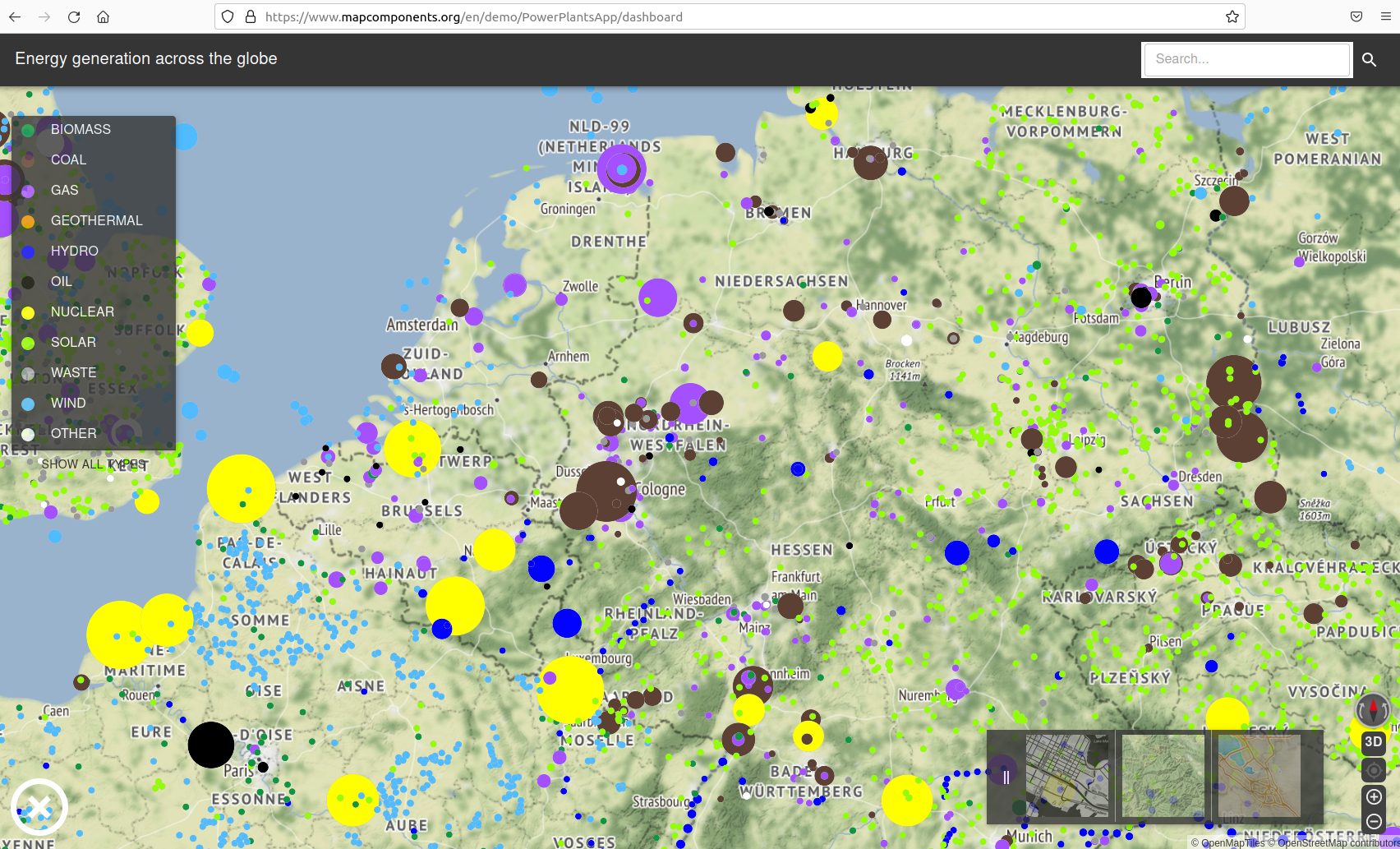
We are currently working (not quite finished yet) on a nice #opensource #webGIS viewer with MapComponents, which is also freely available on #github -> https://github.com/mapcomponents/react-map-components-apps/tree/main /powerplants
The #powerplants theme can of course be changed as you like :)
Just try it here: https://www.mapcomponents.org/en/component-detail/PowerPlantsApp
#opensource #webgis #github #powerplants

avery rose · @av_rose_ev
324 followers · 29 posts · Server mastodon.lolI'm curious how others in #geography define #digitalgeography - I'm working on a paper thinking through how the digital renders/references the geographical and if that's related to how virtual communities are themselves digital geographies
So, how do you define digital geography? Does it mostly refer to things like #GIS #webGIS #cartography #spatialdata that are digital tools we use to reference observable phenomena taking place on the Earth's surface?
#geography #digitalgeography #gis #webgis #cartography #spatialdata
avery rose · @av_rose_ev
484 followers · 44 posts · Server mastodon.lolI'm curious how others in #geography define #digitalgeography - I'm working on a paper thinking through how the digital renders/references the geographical and if that's related to how virtual communities are themselves digital geographies
So, how do you define digital geography? Does it mostly refer to things like #GIS #webGIS #cartography #spatialdata that are digital tools we use to reference observable phenomena taking place on the Earth's surface?
#geography #digitalgeography #gis #webgis #cartography #spatialdata
MapComponents · @mapcomponents
6 followers · 8 posts · Server fosstodon.org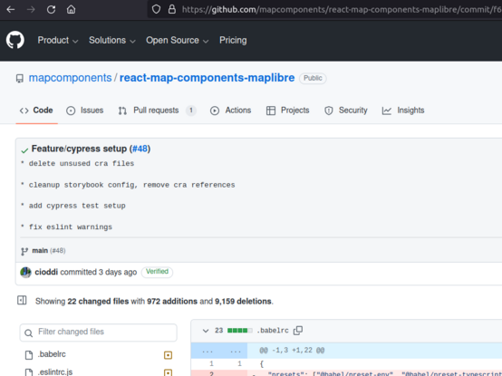
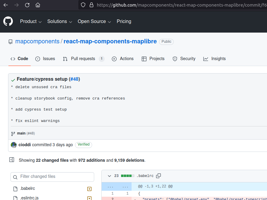
In addition to the unit test, we are now starting to use end-to-end #testing with #Cypress. The first commits are now available on github. https://github.com/mapcomponents/react-map-components-maplibre/commit/f6af0fde96f30385698fc04104c2fd71947de1d9 on the way to an even better #opensource #webgis
#testing #cypress #opensource #webgis
MapComponents · @mapcomponents
6 followers · 6 posts · Server fosstodon.org
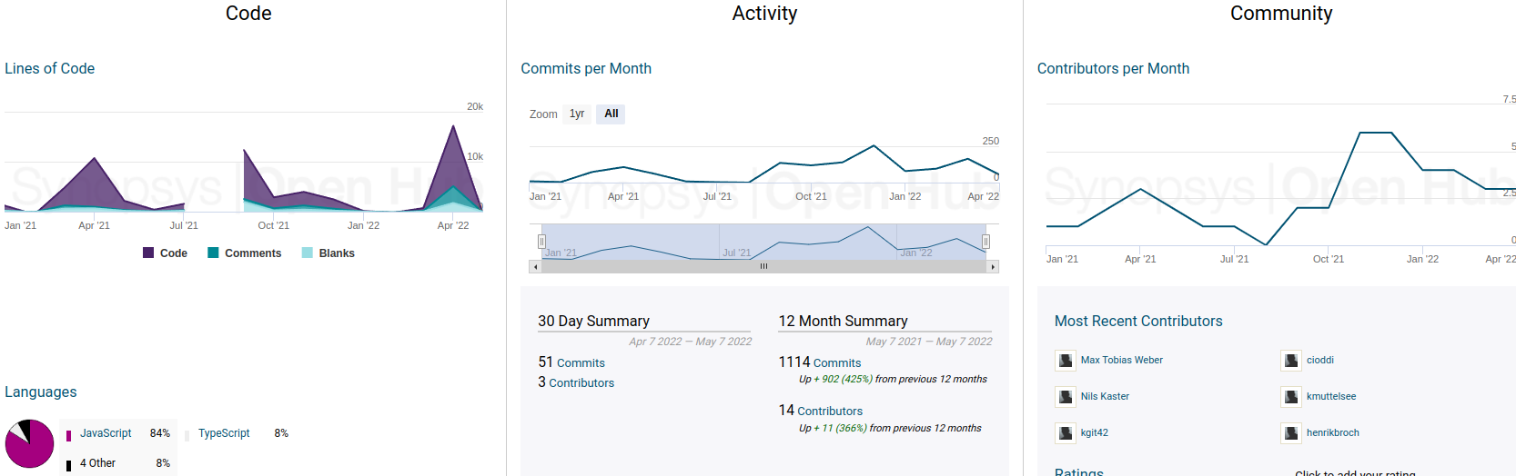
@mapcomponents public on #GitHub #OpenSource the #webgis for #GIS People: -> https://github.com/mapcomponents
Some stats on OpenHub showing the increasing number of commits and contributors https://openhub.net/p/mapcomponents
#github #opensource #webgis #gis