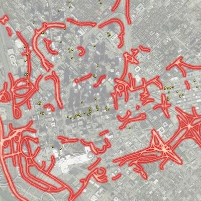
Patrick Kennedy · @WalkableDFW
259 followers · 431 posts · Server urbanists.social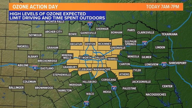
but where will the cars go?
---
RT @marielruizwx
Air Quality Alert - it is an Ozone Action Day. Higher levels of ozone are expected today. Lower air quality is already reported. DFW is at an Orange or "unhealthy for sensitive groups" category. Limit time outdoors if you have respiratory issues. #wfaaweather #iamup
https://twitter.com/marielruizwx/status/1653731192212975616

Pete Delkus · @wfaaweather
7 followers · 1364 posts · Server masto.aiSevere Thunderstorm Warning continues until 5pm for Hopkins, Hunt, Rains and Van Zandt counties. Quarter size hail and 60+mph winds possible. #wfaaweather https://t.co/Lq8iAddqFi
Pete Delkus · @wfaaweather
7 followers · 1362 posts · Server masto.aiSevere Thunderstorm Warning for NE Dallas, Collin, Hunt and Rockwall counties until 3:30 pm. A storm capable of producing half dollar size hail and 60+ mph winds is moving east at 25 mph towards Rockwall Co. #wfaaweather https://t.co/l8jHhMhhBN
Pete Delkus · @wfaaweather
7 followers · 1361 posts · Server masto.aiA storm over Irving has intensified. It could be producing up to penny size hail and gusty winds. Storm is moving east at about 30 mph. #wfaaweather https://t.co/TDvlRELIJt
Pete Delkus · @wfaaweather
7 followers · 1359 posts · Server masto.aiTimecast for Thursday into Friday: Storms form over DFW and move east/southeast. Highest coverage will be across the eastern half of North Texas with western areas mainly dry. Storms clear out by 10-midnight with a mainly dry Friday in store. #wfaaweather https://t.co/agvg0dIEbX
Pete Delkus · @wfaaweather
7 followers · 1357 posts · Server masto.aiMost of North Texas has been in a lull from storms recently, but that changes tomorrow and maybe through the first half of next week as well. #wfaaweather https://t.co/48b6w6XBiI
Pete Delkus · @wfaaweather
7 followers · 1356 posts · Server masto.aiTHURSDAY: T-storms will form along the front between 1-3pm in or around DFW and then move southeast. DFW storm window is around 1-6pm. Main threat with any severe storms will be large hail. Tornado threat is low, but not zero. #wfaaweather https://t.co/0pl5q9PsfA
Pete Delkus · @wfaaweather
7 followers · 1354 posts · Server masto.aiTornado Watch until 11pm but the ONLY county in the WFAA viewing area included is Montague County. Storm chances for there continue to be low, but can't rule out a storm moving in this evening into tonight. #wfaaweather https://t.co/RxwXZLUzUS
Pete Delkus · @wfaaweather
7 followers · 1352 posts · Server masto.ai4:05pm Wednesday: Strong cap continues in North Texas. IF a storm can form, one could move into northwestern areas this evening, but chances are low. DFW storm chances are even lower and the evening is looking dry. #wfaaweather https://t.co/BhgqEYe18Q
Pete Delkus · @wfaaweather
7 followers · 1350 posts · Server masto.aiYou notice it feeling muggier outside? It's not as comfy as it was Monday or this past weekend. Dew points (the measure of moisture in the air) are on the rise and the next few days will feel sticky outside. Good news is drier air returns for the weekend! #wfaaweather https://t.co/BNaco6ZyjI
Pete Delkus · @wfaaweather
7 followers · 1349 posts · Server masto.aiMuch like the last several months, rainfall the rest of the week will favor eastern North Texas vs. western North Texas (where drought continues). DFW will be somewhere in between. Western DFW may not see much vs. eastern DFW could see some decent rain. #wfaaweather https://t.co/ohZIux4BSl
Pete Delkus · @wfaaweather
7 followers · 1347 posts · Server masto.aiUnsettled the rest of this week. Unsettled next week.
In between a mainly dry and much cooler weekend!
#wfaaweather https://t.co/XlxPa2yof0
Pete Delkus · @wfaaweather
7 followers · 1346 posts · Server masto.aiTHURSDAY: Showers and storms are most likely east/southeast of DFW during the day during the afternoon into evening. Overall severe threat for most of North Texas is low, but does increase a bit east/southeast of DFW where some storms could have a wind/hail threat. #wfaaweather https://t.co/1xPkojC5U5
Pete Delkus · @wfaaweather
7 followers · 1345 posts · Server masto.aiWEDNESDAY: A strong cap will limit storm development during the day. But IF the cap breaks during the late afternoon-evening, a couple severe storms are possible mainly across western North Texas with hail/wind. We'll be monitoring it! #wfaaweather https://t.co/9XdFQoEiVH
Pete Delkus · @wfaaweather
6 followers · 1344 posts · Server masto.aiTHURSDAY/FRIDAY: Rain chances are looking a little better especially from DFW to the east. Unfortunately, western NTX may miss out on decent rain again. Some strong to severe storms may be possible for eastern areas as well. We'll keep an eye on it as we get closer! #wfaaweather https://t.co/1QI3M88AfN
Pete Delkus · @wfaaweather
6 followers · 1343 posts · Server masto.aiWarming up this week but another decent cool-down arrives just in time for the weekend. Cool to chilly mornings and below normal afternoons both Saturday and Sunday. #wfaaweather https://t.co/Jltzss4iqB
Pete Delkus · @wfaaweather
6 followers · 1342 posts · Server masto.aiWEDNESDAY: One of those days with a strong cap in place and we'll be watching to see IF a storm can form across western North Texas. IF one does it would likely be severe. This model shows a couple forming, but storms are not guaranteed. #wfaaweather https://t.co/k5N2peePse
Pete Delkus · @wfaaweather
6 followers · 1341 posts · Server masto.aiTUESDAY: Most will be dry, but some spotty showers or even a rumble of thunder are possible. However, severe storms are unlikely in North Texas as the severe threat is low and west of our area closer to the dryline. #wfaaweather https://t.co/zEEKczTPD1
Pete Delkus · @wfaaweather
6 followers · 1339 posts · Server masto.aiNot much change in today's pollen count. Trees still doing their thing. #wfaaweather https://t.co/jBi73TVDRO
Pete Delkus · @wfaaweather
6 followers · 1332 posts · Server masto.aiWarmer weather this week with some storm chances too. Rain coverage and rain amounts will be low this week. The severe threat looks low, but not zero. It is spring after all! #wfaaweather https://t.co/m1eJw8DWOP