Joseph Elfelt · @mappingsupport
509 followers · 442 posts · Server m.ai6yr.org8/27 morning.
Interactive #GIS map for #CampCreekFire SE of #Portland Oregon
Infrared flight last night 10:19pm. IR analyst determined 1,226 acres burned.
Red shading = intense heat.
This watershed is #Portland water supply.
See links for “Map Tips” and “Legend” in upper left corner.
#ORwx #ORfire #WildlandFire
Open #GISsurfer map:
https://mappingsupport.com/p2/gissurfer.php?center=45.451009,-122.092180&zoom=14&basemap=USA_scanned_topo&overlay=VIIRS_7_day,MODIS_7_day,State_boundary&fire=OR,Campcreek&data=https://mappingsupport.com/p2/special_maps/disaster/USA_wildland_fire.txt
#gis #campcreekfire #portland #orwx #orfire #wildlandfire #gissurfer
Joseph Elfelt · @mappingsupport
509 followers · 441 posts · Server m.ai6yr.orgInteractive #GIS map for #CampCreekFire SE of #Portland Oregon and near that town’s water supply.
Dark red symbols are *heat* detections by MODIS and VIIRS satellites within prior 6 hours. This data is not real time, locations are approximate and sometimes ‘false positive”. Two links in upper left corner have more info.
#ORwx #ORfire #WildlandFire #Geospatial #Maps #Mapping #Leaflet #ArcGIS #WebMap
Open #GISsurfer map:
https://mappingsupport.com/p2/gissurfer.php?center=45.452755,-122.097845&zoom=14&basemap=USA_scanned_topo&overlay=VIIRS_7_day,MODIS_7_day,State_boundary&data=https://mappingsupport.com/p2/special_maps/disaster/USA_wildland_fire.txt
#gis #campcreekfire #portland #orwx #orfire #wildlandfire #geospatial #maps #mapping #leaflet #arcgis #webmap #gissurfer
Joseph Elfelt · @mappingsupport
507 followers · 437 posts · Server m.ai6yr.orgInteractive #GIS map for #TigerIslandFire in SW part of #Louisiana. Town of #Merryville just west of the fire has been evacuated.
Dark red symbols are *heat* detections by MODIS and VIIRS satellites within prior 6 hours. This data is not real time, locations are approximate and sometimes ‘false positive”. Two links in upper left corner have more info.
#LAwx #LAfire #WildlandFire #Geospatial #Maps #Mapping #Leaflet #ArcGIS #WebMap
Open #GISsurfer map:
https://mappingsupport.com/p2/gissurfer.php?center=30.765895,-93.492966&zoom=12&basemap=USA_basemap&overlay=VIIRS_7_day,MODIS_7_day,State_boundary,USA_roads&data=https://mappingsupport.com/p2/special_maps/disaster/USA_wildland_fire.txt
#gis #tigerislandfire #louisiana #merryville #lawx #lafire #wildlandfire #geospatial #maps #mapping #leaflet #arcgis #webmap #gissurfer
Joseph Elfelt · @mappingsupport
507 followers · 437 posts · Server m.ai6yr.org@ai6yr Speaking of exit plans, #KingCounty (county seat Seattle) owns various locked gates in the wildland urban interface that could be opened to provide evacuation routes. Currently none of those routes will show up on any evac map.
I have been beating this drum with the county. Now due to the Maui fire and recent fire near Spokane the county has agreed to start looking at this issue. Actual results yet to follow.
#PNW #WildlandFire
#kingcounty #pnw #wildlandfire
Bud Talbot · @bud_t
475 followers · 1385 posts · Server m.ai6yr.orgCheck out this video of a #KMax doing bucket work out of #DiabloLake on the #SourdoughFire, North Cascades NP. These things are amazing.
#kmax #diablolake #sourdoughfire #Wildfire #wildlandfire
Bud Talbot · @bud_t
464 followers · 1347 posts · Server m.ai6yr.orgWe had to use a boat on Ross lake on the #SourdoughFire to do comms checks in a couple of critical areas. Crews were spiked out on an island and were working around the north side of the fire. We needed to confirm that our command repeater covered those areas, hence the boat ride. It all checked out.
#sourdoughfire #Wildfire #wildlandfire
Bud Talbot · @bud_t
464 followers · 1347 posts · Server m.ai6yr.orgAugust 3 is the day the #SourdoughFire really began to take off. These pictures show the power house below Diablo dam and a drop point and spike camp that we had to move as the fire backed down into Diablo.
#Wildfire #wildlandfire #sourdoughfire
Bud Talbot · @bud_t
464 followers · 1343 posts · Server m.ai6yr.orgOn the morning of August 2, things really began to heat up on the #SourdoughFire. These pictures from Diablo show how the fire was backing down towards the houses and dam infrastructure. This series of dams produces a large percentage of the power for the Seattle Metro area. Lots of value at risk.
#sourdoughfire #Wildfire #wildlandfire
Bud Talbot · @bud_t
464 followers · 1343 posts · Server m.ai6yr.orgI'm back from the #SourdoughFire in North Cascades National Park in Washington. It was a great assignment, though challenging to get the comms system up and running. Everything was fly-in only which was cool, but added a layer of work.
I'll share more pics later, but here is a start
#sourdoughfire #Wildfire #wildlandfire
Bud Talbot · @bud_t
440 followers · 1211 posts · Server m.ai6yr.orgBest job on the fire
#ChrisMountainFire #wildfire #wildlandfire #COMT #communications
#chrismountainfire #Wildfire #wildlandfire #comt #communications
Jenny Hansen · @taoofcoffee
263 followers · 248 posts · Server ecoevo.socialUnexpected reminder of the fire that nearly took my home and which likely took several years off of my life. Working 16 hours a day on the fire that threatens your home while also being evacuated in a tiny hotel room w/3 kids is not an experience I'd wish on my enemies.
A lookback at the 2013 Mount Charleston fire, 10 years later https://www.reviewjournal.com/local/local-las-vegas/looking-back-on-one-of-mount-charlestons-largest-fires-10-years-later-2802771/
>The Carpenter 1 fire at Mount Charleston in 2013 burned nearly 28,000 acres. Now, the land is slowly recovering.
Kurious1 · @Kurious1
151 followers · 2652 posts · Server mas.toIs it too much to ask for weather conditions in Alberta or Iraq or Afghanistan? Or wherever you find your children? #Alberta #USA #wildlandfire #iraq #afghanistan #weather
#weather #afghanistan #iraq #wildlandfire #USA #alberta
Mapping Support · @mappingsupport
84 followers · 8 posts · Server m.ai6yr.orgIntroduction.
I am the developer of #GISsurfer which is a general purpose web map with broad support for displaying GIS data. GISsurfer videos and PDFs: https://mappingsupport.com/p2/gissurfer-help.html
Curated list of 3,000+ government #ArcGIS server addresses: https://mappingsupport.com/p/surf_gis/list-federal-state-county-city-GIS-servers.pdf
List is updated each week.
GeoJPG (under development) is a Progressive Web App that displays georeferenced JPGs that you can make with GISsurfer’s Menu > Screenshot mode.
#gissurfer #arcgis #maps #mapping #gis #geospatial #hiking #wildlandfire #pwa
Bud Talbot · @bud_t
352 followers · 679 posts · Server m.ai6yr.orgI'm spending some time lately wearing this old friend, the 20.5 kg weight vest, in preparation for next week's pack test. It's the last thing to do for the annual #firefighter recertification.
#firefighter #wildlandfire #Wildfire
Brandon Morgan · @bmorgan83
21 followers · 143 posts · Server mastodon.worldLooking for more #wildlandfire tracking accounts… particularly if anyone knows of a NWS Prediction Center bot that is more up to date, the one I found is a week behind. Trying to gauge when I’m gonna be going out into the South West this year… last year I was out April 13th for Hermits Peak.
Bud Talbot · @bud_t
335 followers · 532 posts · Server m.ai6yr.orgNew StoryMap from Joint Fire Science Program Exchange Network: "Fire in the Western U.S.: Big fires. Big challenges. Big need for regional learning & action."
#wildfire #wildlandfire @wildfirescience
https://storymaps.arcgis.com/stories/7476b32992b843a28fcf2f5c8effc96d
Bud Talbot · @bud_t
307 followers · 208 posts · Server m.ai6yr.orgRT-130 refresher training completed. My Red Card is current for the next year. Let's be Firewise and fight fire
Bill Rhodes · @Brhodes
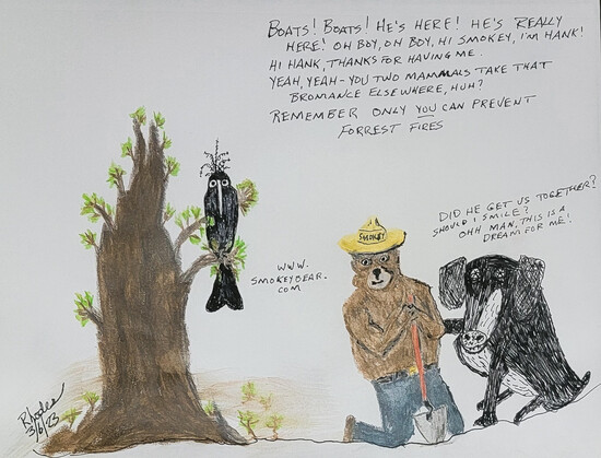
301 followers · 432 posts · Server universeodon.comAs more of us head out for outdoor adventure, make sure your fires are OUT
#usfs #ushotshots #hotshot #smokejumpers #forestservice #helitack #wildlandfire #smokeythebear #preventfires #hankandboats #cartoon #dogsofmastodon #starstruck #watercolour
www.Smokeybear.com for more
#usfs #ushotshots #hotshot #smokejumpers #forestservice #helitack #wildlandfire #smokeythebear #preventfires #hankandboats #cartoon #dogsofmastodon #starstruck #watercolour
Bud_T · @bud_t
287 followers · 461 posts · Server fosstodon.orgA good read about life as a #wildlandfire fighter. And very well written. #wildfire
Backbone Contributor - Michael Lowden | MYSTERY RANCH Backpacks
https://www.mysteryranch.com/backbone-michael-lowden
Deborah Lee Soltesz · @dsoltesz
22 followers · 92 posts · Server az.social"The sites targeted for spending in 2023 cover much of Southern California, home to 25 million people; the Klamath River Basin on the Oregon-California border; San Carlos Apache Reservation lands in Arizona; and the Wasatch area of northern Utah, a tourist draw with seven ski resorts. Other sites are in Idaho, Oregon, Nevada, Washington state, Colorado, New Mexico and Montana."
Not sure why "crisis" is in quotes. #Wildfire #AZFire #WildlandFire #ClimateChange #Arizona
https://apnews.com/article/wildfires-science-politics-health-oregon-fd0b4b56e97fca9a6e083096f2bc97f4
#wildfire #AZFire #wildlandfire #climatechange #arizona


