WACOCA · @wacoca
31 followers · 8175 posts · Server mastodon.cloud【Tatsuro Yamashita】山下 達郎 アルバム 2023 🎸 山下 達郎 メドレー2023 https://www.wacoca.com/videos/1766153/celebrity/
#70's #80's #90's #Celebrities #Celebrity #CityPop #citypopcompilation #japanese #jpop #Music #PlasticLove #pop #popmusic #RIDEONTIME #Tatsuro #TatsuroYamashita #Vlog #worldpop #Yamashita山下 #アルバム #メドレー2023 #山下 #山下達郎 #山下達郎 #山下達郎rideontime #山下達郎sparkle #山下達郎アルバム #山下達郎クリスマスイブ #山下達郎メドレー #達郎
#celebrities #celebrity #citypop #citypopcompilation #japanese #jpop #music #plasticlove #pop #popmusic #rideontime #Tatsuro #tatsuroyamashita #vlog #worldpop #yamashita山下 #アルバム #メドレー2023 #山下 #山下達郎 #山下達郎rideontime #山下達郎sparkle #山下達郎アルバム #山下達郎クリスマスイブ #山下達郎メドレー #達郎
BNHR.XYZ :tux: :qgis: · @bnhrdotxyz
47 followers · 24 posts · Server fosstodon.org3a. For the first visualization:
- Apply a graduated symbology or "data-defined" symbology using the pop_sum field.
3b. For the second visualization:
- Use geometry generators and the "scale" expression with pop_sum and max(pop_sum) to create the bar/column graph.
🧵 4/4
#GIS #QGIS #Geospatial #Philippines #Maps #Cartography #MakeBetterMaps #Population #WorldPop #gischat #DataViz #DataVisualization
#gis #qgis #geospatial #philippines #maps #cartography #MakeBetterMaps #population #worldpop #gischat #dataviz #datavisualization
BNHR.XYZ :tux: :qgis: · @bnhrdotxyz
47 followers · 23 posts · Server fosstodon.org1. Used QGIS' "Create grid" algorithm to generate a grid of 30 second (or longitudes) covering the extent of the Philippines.
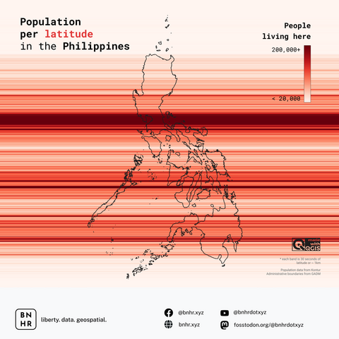
2. Used the "Zonal Statistics" algorithm to compute for the sum of population (pop_sum) for each latitude (or longitude) using the WorldPop population data.
🧵 3/4
#GIS #QGIS #Geospatial #Philippines #Maps #Cartography #MakeBetterMaps #Population #WorldPop #gischat
#gis #qgis #geospatial #philippines #maps #cartography #MakeBetterMaps #population #worldpop #gischat
BNHR.XYZ :tux: :qgis: · @bnhrdotxyz
47 followers · 22 posts · Server fosstodon.orgThe data used are a population raster (30 second/1km grid) from WorldPop and Philippine admin boundary map from GADM.
The first map visualizes the population per 30 second of latitude (or longitude) using color while the second visualizes the population as a bar/column chart.
The process was once again fairly straightforward.
🧵 2/4
#GIS #QGIS #Geospatial #Philippines #Maps #Cartography #MakeBetterMaps #Population #WorldPop #gischat
#gis #qgis #geospatial #philippines #maps #cartography #MakeBetterMaps #population #worldpop #gischat
BNHR.XYZ :tux: :qgis: · @bnhrdotxyz
47 followers · 21 posts · Server fosstodon.orgFriday is map day! Were you waiting for new maps/visualizations of Philippine population? Well, you're in luck because here's #anotherone (or four really).
This time they are maps of population per latitude (and longitude) in the Philippines. As usual, all the processing and map-making was done in QGIS.
🧵 1/4
#GIS #QGIS #Geospatial #Philippines #Maps #Cartography #MakeBetterMaps #Population #WorldPop #gischat
#anotherone #gis #qgis #geospatial #philippines #maps #cartography #MakeBetterMaps #population #worldpop #gischat

